The Cotswold Way
Cicerone Press (Verlag)
978-1-85284-816-3 (ISBN)
- Titel ist leider vergriffen;
keine Neuauflage - Artikel merken
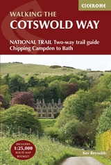
Guidebook to walking the Cotswold Way National Trail between Chipping Campden and Bath, across the Cotswolds AONB - which includes both a guide to the route and a separate mapping booklet. The 102 mile (163km) route is described in both directions over 13 stages, of between 6 and 10 miles, depending on the existence of overnight accommodation. Camping options are sparse along the route.
This guidebook is illustrated with maps and the author's own full-colour photographs. The stage-by-stage route description is accompanied by overview maps at a scale of 1:100,000 (1cm to 1 mile). A more detailed map of the Way is supplied in booklet form, at a scale of 1:25,000, slid into the back of the book.
The Cotswold Way became a National Trail in May 2007, despite having been a much-loved walking route for more than 35 years. It follows the Cotswold escarpment, with dramatic and far-reaching views across the Severn Vale towards the Welsh hills, plunging down to visit honey-coloured villages, old market towns and the elegant and historic city of Bath.
Kev Reynolds is a freelance writer, photojournalist and lecturer. A prolific compiler of guidebooks, his first title for Cicerone Press (Walks & Climbs in the Pyrenees) appeared in 1978; he has since produced many more titles for the same publisher, with others in the pipeline. A member of the Outdoor Writers- Guild, the Alpine Club and Austrian Alpine Club, his passion for mountains and the countryside remains undiminished after a lifetime's activity, and he regularly travels throughout Britain to share that enthusiasm through his lectures.
CONTENTS
Map key
Overview map and profile
Route summary tables
Trek planner
Introduction
The Cotswold Way
Planning your trip
Choosing an itinerary
Which way to walk?
When to go?
Self-guided or guided?
Getting there and getting around
First nights and last nights
Accommodation
Facilities en route
Baggage transfer service
What to take
The Cotswold Way Hall of Fame
Planning day by day
Using this guide
Additional mapping
Waymarking
Health, safety and emergencies
Mobile phones, wi-fi and the internet
The Country Code
All about the Cotswolds
Geology
Plants and wildlife
Man in the landscape
Southbound: Chipping Campden to Bath
Introduction
Stage 1 Chipping Campden to Stanton
Stage 2 Stanton to Winchcombe
Stage 3 Winchcombe to Cleeve Hill
Stage 4 Cleeve Hill to Dowdeswell (A40)
Stage 5 Dowdeswell (A40) to Birdlip
Stage 6 Birdlip to Painswick
Stage 7 Painswick to Middleyard (King's Stanley)
Stage 8 Middleyard (King's Stanley) to Dursley
Stage 9 Dursley to Wotton-under-Edge
Stage 10 Wotton-under-Edge to Hawkesbury Upton
Stage 11 Hawkesbury Upton to Tormarton
Stage 12 Tormarton to Cold Ashton
Stage 13 Cold Ashton to Bath
Northbound: Bath to Chipping Campden
Introduction
Stage 1 Bath to Cold Ashton
Stage 2 Cold Ashton to Tormarton
Stage 3 Tormarton to Hawkesbury Upton
Stage 4 Hawkesbury Upton to Wotton-under-Edge
Stage 5 Wotton-under-Edge to Dursley
Stage 6 Dursley to Middleyard (King's Stanley) 2
Stage 7 Middleyard (King's Stanley) to Painswick
Stage 8 Painswick to Birdlip
Stage 9 Birdlip to Dowdeswell (A40)
Stage 10 Dowdeswell (A40) to Cleeve Hill
Stage 11 Cleeve Hill to Winchcombe
Stage 12 Winchcombe to Stanton
Stage 13 Stanton to Chipping Campden
Appendix A Useful contacts
Appendix B Accommodation along the route
Appendix C Further reading
| Erscheint lt. Verlag | 22.5.2023 |
|---|---|
| Reihe/Serie | Cicerone guidebooks |
| Verlagsort | Kendal |
| Sprache | englisch |
| Maße | 116 x 172 mm |
| Gewicht | 340 g |
| Themenwelt | Sachbuch/Ratgeber ► Sport |
| Reisen ► Sport- / Aktivreisen ► Europa | |
| ISBN-10 | 1-85284-816-2 / 1852848162 |
| ISBN-13 | 978-1-85284-816-3 / 9781852848163 |
| Zustand | Neuware |
| Informationen gemäß Produktsicherheitsverordnung (GPSR) | |
| Haben Sie eine Frage zum Produkt? |
aus dem Bereich