


Collins Pocket Map Ireland
Seiten
2015
|
New edition
Collins (Verlag)
978-0-00-810227-2 (ISBN)
Collins (Verlag)
978-0-00-810227-2 (ISBN)
- Titel erscheint in neuer Auflage
- Artikel merken
Zu diesem Artikel existiert eine Nachauflage
Scale: 7.5 miles to 1 inch.
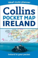
Handy little full colour map of Ireland at an excellent price. It is double-sided, with the south of Ireland up to and including Dublin on one side, and from Dublin northwards on the other. Ideal for the pocket, bag or glovebox of the car.
INCLUDES
• All the latest road changes
• Places of interest
• Ferry routes
• Speed enforcement zones and safety camera locations
AREA OF COVERAGE
Covers the whole of Ireland on a double-sided sheet: with the south of Ireland up to Dublin on one side and the north of Ireland from just south of Dublin on the other.
WHO THE PRODUCT IS OF INTEREST TO
Essential for those planning a trip or who want a cheap and easy to use back up for a sat nav.
Explore the world through accurate and up-to-date mapping.
| Erscheint lt. Verlag | 15.1.2015 |
|---|---|
| Verlagsort | London |
| Sprache | englisch |
| Maße | 90 x 140 mm |
| Gewicht | 40 g |
| Themenwelt | Reisen ► Karten / Stadtpläne / Atlanten ► Europa |
| ISBN-10 | 0-00-810227-9 / 0008102279 |
| ISBN-13 | 978-0-00-810227-2 / 9780008102272 |
| Zustand | Neuware |
| Haben Sie eine Frage zum Produkt? |
Mehr entdecken
aus dem Bereich


aus dem Bereich
Straßen- und Freizeitkarte 1:250.000
Karte (gefalzt) (2023)
Freytag-Berndt und ARTARIA (Verlag)
12,90 €
Karte (gefalzt) (2023)
Freytag-Berndt und ARTARIA (Verlag)
12,90 €
Narvik
Karte (gefalzt) (2023)
Freytag-Berndt und ARTARIA (Verlag)
12,90 €