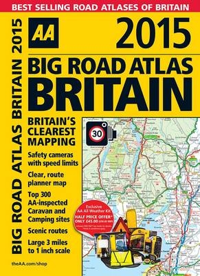
AA Big Road Atlas Britain 2015
2014
|
24th Revised edition
Automobile Association (Verlag)
978-0-7495-7605-9 (ISBN)
Automobile Association (Verlag)
978-0-7495-7605-9 (ISBN)
- Titel ist leider vergriffen;
keine Neuauflage - Artikel merken
AA Big Road Atlas Britain 2015 is a best-selling, 3 miles to 1 inch scale, A3 format atlas available in two binding styles, softback and spiral bound. Each page has been titled with its geographical location so you can turn to the page you need more easily. Static speed camera locations with speed limits are pinpointed and wide minor roads (more than and less than 4m wide) are indicated. National Trust, English and World Heritage sites, crematorium locations and other hard-to-find places are also shown. There are 66 city, town and port plans including central London. Plus, scenic routes, tourist sites with satnav friendly post codes and caravan and camping sites symbolised on the maps.
AA Publishing is the UK's largest travel publisher, with an extensive range of inspiring travel guides, dependable driving books, and trusted maps and atlases.
| Erscheint lt. Verlag | 1.7.2014 |
|---|---|
| Zusatzinfo | Scale: 3 miles to 1 inch |
| Verlagsort | Basingstoke |
| Sprache | englisch |
| Maße | 283 x 390 mm |
| Themenwelt | Reisen ► Karten / Stadtpläne / Atlanten ► Europa |
| Reiseführer ► Europa ► Großbritannien | |
| ISBN-10 | 0-7495-7605-7 / 0749576057 |
| ISBN-13 | 978-0-7495-7605-9 / 9780749576059 |
| Zustand | Neuware |
| Haben Sie eine Frage zum Produkt? |
Mehr entdecken
aus dem Bereich
aus dem Bereich
individuell reisen mit vielen praktischen Tipps
Buch | Softcover (2024)
Michael Müller (Verlag)
29,90 €
Reiseführer mit Stadtplan, 4 Spaziergängen und kostenloser Web-App
Buch | Softcover (2023)
Reise Know-How (Verlag)
15,95 €
Buch | Softcover (2023)
Reise Know-How (Verlag)
24,95 €


