The GR5 Trail
Cicerone Press (Verlag)
978-1-85284-729-6 (ISBN)
- Titel ist leider vergriffen;
keine Neuauflage - Artikel merken
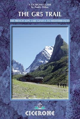
The final section of the GR5, also known as the Grande Traversée des Alpes, runs from the shores of Lac Léman, over the French Alps, to reach the Mediterranean coastline at Nice. The route measures 674 kilometres (420 miles) and can be covered in a month, or split over a series of summer trips. This guidebook also includes some great variant routes, such as the stunning GR55 through the Vanoise National Park and the GR52 through the Mercantour National Park to finish at Menton. Every section of route description is illustrated with clear colour mapping and gradient profiles, as well as inspirational photographs. The GTA trek is achievable by any fit and experienced walker and this guidebook suggests daily stages, timings, ascents and descents, and lists all the facilities and services available along the way from start to finish. People have been crossing the Alps for many centuries but today's journey is much easier than that of those who have gone before. With some advance thought and planning, coupled with a willingness to adapt your plans day-by-day if necessary, a walk along the GR5 should present a fine and memorable challenge.
Paddy Dillon is a prolific outdoor writer with over 50 books to his name, as well as contributions to many more. He also writes for a number of outdoor magazines. He has walked throughout Europe, including completing the GR5 twice, and has also walked in Nepal, Tibet, Canada and the US. Paddy is a member of the Outdoor Writers and Photographers Guild.
Contents
Introduction
Walking the GR5
Alpine Traverses
Who Walks the GR5?
Route Outline
North-South/South-North
Timings
Waymarking
GR5 Geology
Alpine Flowers
Alpine Wildlife
Alpine Farming
Pastous
Language
Travel to the Alps
Travel Around the Alps
Services on the GR5
Accommodation
Food and Drink
Telephones
Path Conditions
Alpine Weather
When to Walk the GR5
Kit Check
Maps
Currency and Costs
Emergencies
Key Points
Stage 1 Lac Léman to Les Houches
Day 1 St Gingolph to La Chapelle d'Abondance (direct route)
Day 1a Thonon-les-Bains to Chevenoz (alternative Day 1)
Day 2a Chevenoz to La Chapelle d'Abondance (alternative Day 2)
Day 3 La Chapelle d'Abondance to Chésery
Day 4 Chésery to Samoëns
Day 5 Samoëns to Refuge de Moëde Anterne
Day 6 Refuge de Moëde Anterne to Les Houches
Stage 2 Les Houches to Landry
Day 7 Les Houches to Les Contamines
Day 7a Les Houches to Les Contamines (high-level route)
Day 8 Les Contamines to Plan de la Lai
Day 9 Plan de la Lai to Landry
Stage 3 Landry to Modane
GR5 Route
Day 10 Landry to Refuge d'Entre-le-Lac
Day 11 Refuge d'Entre-le-Lac to Val d'Isère
Day 12 Val d'Isère to Bessans
Day 13 Bessans to Refuge du Plan du Lac
Day 14 Refuge du Plan du Lac to Le Montana
Day 15 Le Montana to Modane/Fourneaux
GR55 High-level route (Refuge d'Entre-le-Lac to Modane)
Day 11 Refuge d'Entre-le-Lac to Refuge d'Entre Deux Eaux
Day 12 Refuge d'Entre Deux Eaux to Roc de la Pêche
Day 13 Roc de la Pêche to Modane/Fourneaux
GR5E Low-level route (Bonneval-sur-Arc to Modane)
Day 13 Bonneval-sur-Arc to Lanslevillard
Day 14 Lanslevillard to Bramans
Day 15 Bramans to Modane/Fourneaux
Stage 4 Modane to Ceillac
Day 16 Modane/Fourneaux to Refuge du Thabor
Day 17 Refuge du Thabor to Plampinet
Day 17a La Vallée étroite to Plampinet (GR5B alternative)
Day 18 Plampinet to Briançon
Day 18a Névache to Briançon (GR5C alternative)
Day 19 Briançon to Brunissard
Day 20 Brunissard to Ceillac
Stage 5 Ceillac to Auron
Day 21 Ceillac to La Barge/Maljasset
Day 22 La Barge/Maljasset to Larche
Day 23 Larche to Bousieyas
Day 24 Bousieyas to Auron
Stage 6 Auron to Nice - GR5
Day 25 Auron to Refuge de Longon
Day 26 Refuge de Longon to St Dalmas
Day 27 St Dalmas to Utelle
Day 28 Utelle to Aspremont
Day 29 Aspremont to Nice
Stage 7 St Dalmas to Garavan/Menton - GR52
Day 27 St Dalmas to Le Boréon
Day 28 Le Boréon to Refuge de Nice
Day 29 Refuge de Nice to Refuge des Merveilles
Day 30 Refuge des Merveilles to Sospel
Day 31 Sospel to Garavan/Menton
Appendix 1 Route Summary - North to South
Appendix 2 Route Summary - South to North
Appendix 3 Accommodation List
Appendix 4 Basic French for the GR5
Appendix 5 Topographical Glossary
| Erscheint lt. Verlag | 14.2.2013 |
|---|---|
| Zusatzinfo | Over 100 colour photos and 100 maps and profiles |
| Verlagsort | Kendal |
| Sprache | englisch |
| Maße | 116 x 172 mm |
| Gewicht | 390 g |
| Themenwelt | Sachbuch/Ratgeber ► Sport |
| Reiseführer ► Europa ► Frankreich | |
| ISBN-10 | 1-85284-729-8 / 1852847298 |
| ISBN-13 | 978-1-85284-729-6 / 9781852847296 |
| Zustand | Neuware |
| Haben Sie eine Frage zum Produkt? |
aus dem Bereich


