


Discovering Glasgow Illustrated Map
2013
Collins (Verlag)
978-0-00-749382-1 (ISBN)
Collins (Verlag)
978-0-00-749382-1 (ISBN)
- Titel erscheint in neuer Auflage
- Artikel merken
Zu diesem Artikel existiert eine Nachauflage
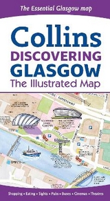
Glasgow, host of the 2014 Commonwealth Games, is on the itinerary of many visitors to Scotland. This new map displays delightful watercolour mapping, with individual paintings of all the main sights and landmarks in the city.
Covers the centre of Glasgow from the Botanic Gardens in the north and the new Riverside Museum to the west to the 12th century Cathedral and the gritty Barras Market to the east.
Further mapping stretches southwest to Pollok Park and the Burrell Collection.
The map features:
• Historical and contemporary anecdotes.
• Popular areas at larger scale, hundreds of shops, restaurants, cafés and bars.
• Comprehensive travel information and index.
• Shop by shop street maps of Buchanan Street and the Merchant City.
• Railway stations, bus routes, taxi ranks and car parks.
Commonwealth Games venues shown on front of map – SECC precinct (Gymnastics, Boxing, Judo, Netball, Wrestling and Weightlifting/Powerlifting), Kelvingrove Lawn Bowls Centre (Lawn Bowls). These are shown in large scale and would be ideal for anyone attending these venues as map also shows restaurants and other facilities nearby.
The back of the map has further out map which includes the locations of Emirates Arena and Velodrome (Cycling and Badminton), Hampden park (Athletics), Celtic Park (opening and closing ceremony), Glasgow National Hockey Centre (Hockey), Ibrox (Rugby 7s) and athletes village.
Tollcross International Swimming Centre, Strathclyde Park (mountain biking), Scotstoun Sports Campus (Squash) and Cathkin Braes Mountain Bike Park are all just outside the further out map area but marked with an arrow on the map itself.
Dominic Beddow produces informative maps of cities from Amsterdam to Zanzibar. This Glasgow map is an new addition to his range of maps for Collins which also include Dublin, London and Edinburgh. The maps are checked on foot, bicycle or scooter and then peppered with useful description, whimsy, humour and historical anecdote.
| Erscheint lt. Verlag | 9.5.2013 |
|---|---|
| Zusatzinfo | Maps |
| Verlagsort | London |
| Sprache | englisch |
| Maße | 113 x 205 mm |
| Gewicht | 50 g |
| Themenwelt | Reisen ► Karten / Stadtpläne / Atlanten ► Europa |
| ISBN-10 | 0-00-749382-7 / 0007493827 |
| ISBN-13 | 978-0-00-749382-1 / 9780007493821 |
| Zustand | Neuware |
| Informationen gemäß Produktsicherheitsverordnung (GPSR) | |
| Haben Sie eine Frage zum Produkt? |
Mehr entdecken
aus dem Bereich


aus dem Bereich
Straßen- und Freizeitkarte 1:250.000
Karte (gefalzt) (2023)
Freytag-Berndt und ARTARIA (Verlag)
12,90 €
Narvik
Karte (gefalzt) (2023)
Freytag-Berndt und ARTARIA (Verlag)
12,90 €
Karte (gefalzt) (2023)
Freytag-Berndt und ARTARIA (Verlag)
12,90 €