England And Wales Classic, Tubed
Wall Maps Countries & Regions
Seiten
2012
National Geographic Maps (Verlag)
978-1-59775-487-3 (ISBN)
National Geographic Maps (Verlag)
978-1-59775-487-3 (ISBN)
- Titel nicht im Sortiment
- Artikel merken
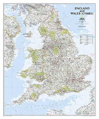
This classic-style map of England and Wales shows political boundaries, major highways and roads, cities and towns, airports and other geographic details. Thousands of place-names and exact borders are carefully researched by National Geographic s map researchers and editors ensuring the utmost accuracy. Scale: 1:868,000. Tubed. 91.4 x 76.2 cm.
| Erscheint lt. Verlag | 2.8.2012 |
|---|---|
| Verlagsort | Evergreen |
| Sprache | englisch |
| Maße | 56 x 820 mm |
| Gewicht | 188 g |
| Themenwelt | Reisen ► Karten / Stadtpläne / Atlanten ► Welt / Arktis / Antarktis |
| ISBN-10 | 1-59775-487-0 / 1597754870 |
| ISBN-13 | 978-1-59775-487-3 / 9781597754873 |
| Zustand | Neuware |
| Haben Sie eine Frage zum Produkt? |
Mehr entdecken
aus dem Bereich
aus dem Bereich
1:30 Mio. mit Posterleisten, mit Oberflächenlaminat
Karte (gerollt) (2023)
INTERKART Landkarten & Globen (Verlag)
25,90 €


