Philip's British Isles Wall Map
2000
|
New edition
Philip's (Verlag)
978-0-540-07868-4 (ISBN)
Philip's (Verlag)
978-0-540-07868-4 (ISBN)
- Titel ist leider vergriffen;
keine Neuauflage - Artikel merken
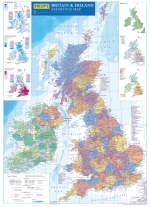
This wall map is created from the latest in digital cartography. It features a brightly coloured large-scale map of the British Isles, in political coloration. Counties and administrative areas are picked out in disctinctive colours to aid identification, with town names clearly shown. Also included on the chart alongside the large political map is a physical map of the British Isles, together with smaller thematic maps covering the important areas of population, rainfall, wealth and transport.
| Zusatzinfo | Col.M. |
|---|---|
| Verlagsort | London |
| Sprache | englisch |
| Maße | 145 x 263 mm |
| Gewicht | 110 g |
| Themenwelt | Reisen ► Karten / Stadtpläne / Atlanten ► Europa |
| Naturwissenschaften ► Geowissenschaften ► Geografie / Kartografie | |
| ISBN-10 | 0-540-07868-9 / 0540078689 |
| ISBN-13 | 978-0-540-07868-4 / 9780540078684 |
| Zustand | Neuware |
| Haben Sie eine Frage zum Produkt? |
Mehr entdecken
aus dem Bereich
aus dem Bereich
Straßen- und Freizeitkarte 1:250.000
Karte (gefalzt) (2023)
Freytag-Berndt und ARTARIA (Verlag)
12,90 €
Karte (gefalzt) (2023)
Freytag-Berndt und ARTARIA (Verlag)
12,90 €
Narvik
Karte (gefalzt) (2023)
Freytag-Berndt und ARTARIA (Verlag)
12,90 €


