


West Indies
Tourist Islands
1999
MapQuest.com (Verlag)
978-1-57262-320-0 (ISBN)
MapQuest.com (Verlag)
978-1-57262-320-0 (ISBN)
- Titel erscheint in neuer Auflage
- Artikel merken
Zu diesem Artikel existiert eine Nachauflage
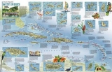
Ideal for reference or display, these finely detailed political maps feature National Geographic's distinctive cartographic style, with colorful boundaries and beautiful shaded relief.Colorful overview of the Caribbean Islands and Central America, with detailed maps of the 39 most popular tourist islands on the other side.
| Erscheint lt. Verlag | 1.9.1999 |
|---|---|
| Reihe/Serie | NG Country & Region Maps |
| Zusatzinfo | M. |
| Verlagsort | New York |
| Sprache | englisch |
| Maße | 580 x 860 mm |
| Gewicht | 130 g |
| Themenwelt | Reisen ► Karten / Stadtpläne / Atlanten ► Nord- / Mittelamerika |
| ISBN-10 | 1-57262-320-9 / 1572623209 |
| ISBN-13 | 978-1-57262-320-0 / 9781572623200 |
| Zustand | Neuware |
| Haben Sie eine Frage zum Produkt? |
Mehr entdecken
aus dem Bereich


aus dem Bereich
Karte (gefalzt) (2024)
Freytag-Berndt und ARTARIA (Verlag)
12,90 €
Karte (gefalzt) (2023)
Reise Know-How (Verlag)
12,00 €
Karte (gefalzt) (2023)
Reise Know-How (Verlag)
12,00 €