


Sulawesi Travel Map
2012
|
5th Revised edition
Periplus Editions (Verlag)
978-0-7946-0701-2 (ISBN)
Periplus Editions (Verlag)
978-0-7946-0701-2 (ISBN)
- Titel erscheint in neuer Auflage
- Artikel merken
Zu diesem Artikel existiert eine Nachauflage
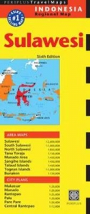
The Sulawesi Travel Map from Periplus is designed as a convenient, easy-to-use tool for travelers. Created using durable coated paper, this map is made to open and fold multiple times, whether it's the entire map that you want to view or one panel at a time. Following highways and byways, this map will show you how to maneuver your way to banks, gardens, hotels, golf courses, museums, monuments, restaurants, churches and temples, movie theaters, shopping centers and more!
This 5th edition includes maps and plans that are scaled to:
Area Maps: Sulawesi 1:2,600,000 South Sulawesi 1:1,000,000 North Sulawesi 1:850,000 Tana Toraja 1:150,000 Manado Area, Sangihe Area, Talaud Area 1:450,000
City Plans: Makassar, Manado 1:20,000 Rantepao 1:25,000 Palu, Parepare 1:20,000 Central Rantepao 1:12,000Periplus Travel Maps cover most of the major cities and travel destinations in the Asia-Pacific region. The series includes an amazing variety of fascinating destinations, from the multifaceted subcontinent of India to the bustling city-state of Singapore and the 'western style' metropolis of Sydney to the Asian charms of Bali. All titles are continuously updated, ensuring they keep up with the considerable changes in this fast-developing part of the world. This extensive geographical reach and attention to detail mean that Periplus Travel Maps are the natural first choice for anyone traveling in the region.
| Erscheint lt. Verlag | 30.8.2012 |
|---|---|
| Zusatzinfo | Maps; Illustrations, color |
| Verlagsort | Boston |
| Sprache | englisch |
| Maße | 108 x 260 mm |
| Themenwelt | Reisen ► Karten / Stadtpläne / Atlanten ► Asien |
| ISBN-10 | 0-7946-0701-2 / 0794607012 |
| ISBN-13 | 978-0-7946-0701-2 / 9780794607012 |
| Zustand | Neuware |
| Haben Sie eine Frage zum Produkt? |
Mehr entdecken
aus dem Bereich

aus dem Bereich
Karte (gefalzt) (2024)
Freytag-Berndt und ARTARIA (Verlag)
12,90 €
Karte (gefalzt) (2023)
Reise Know-How (Verlag)
14,00 €
reiß- und wasserfest (world mapping project)
Karte (gefalzt) (2024)
Reise Know-How (Verlag)
12,00 €