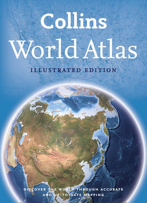
Collins World Atlas: Illustrated Edition
Seiten
2012
Collins (Verlag)
978-0-00-745265-1 (ISBN)
Collins (Verlag)
978-0-00-745265-1 (ISBN)
- Titel ist leider vergriffen;
keine Neuauflage - Artikel merken
A paperback edition of this fully revised general reference atlas in the exciting Collins world atlas range. Highly detailed maps giving balanced worldwide coverage, beautifully illustrated thematic pages and thousands of facts and statistics.
This perfect family reference atlas provides a comprehensive and topical view of today’s world and the issues facing it.
The contents include:
• Highly detailed reference maps, with beautifully illustrated thematic pages which include facts and tables plus a fully revised world statistics section with thousands of country statistics that enable the reader to learn more about the world.
• Highly illustrated thematic pages provide detailed information on, and interpretations of, major geographical themes and global issues.
• Over 150 pages of highly accurate and fully up-to-date maps with an index of over 50,000 place names (10,000 more than the nearest competitor at this price).
• Global issues including the environment, world conflict, population, climate change and the international drugs trade.
• Comparative satellite images show dramatic examples of environmental change e.g. deforestation.
• Highly detailed, updated regional and world-wide mapping.
Updates include:
• World’s newest country South Sudan.
• Netherlands Antilles now dissolved.
• Samoa and Tokelau jump the dateline.
• Over 1,000 names updated.
• 2012 north and south pole positions.
• Updated administrative division names and capitals.
• Aral Sea continues to shrink, as does the Dead Sea, its surface height now -421m below sea level.
• Many new and enlarged national parks, new railways and international airports.
Explore the world through accurate and up-to-date mapping.
| Erscheint lt. Verlag | 26.4.2012 |
|---|---|
| Verlagsort | London |
| Sprache | englisch |
| Maße | 226 x 312 mm |
| Gewicht | 1140 g |
| Themenwelt | Reisen ► Karten / Stadtpläne / Atlanten ► Welt / Arktis / Antarktis |
| ISBN-10 | 0-00-745265-9 / 0007452659 |
| ISBN-13 | 978-0-00-745265-1 / 9780007452651 |
| Zustand | Neuware |
| Haben Sie eine Frage zum Produkt? |
Mehr entdecken
aus dem Bereich
aus dem Bereich
mit Fakten und Infos zu allen Kontinenten
Buch | Hardcover (2024)
Kosmos Kartografie in der Franckh-Kosmos Verlags-GmbH & Co. …
24,00 €


