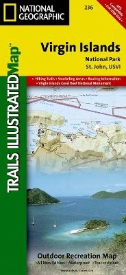
Virgin Islands National Park
Trails Illustrated National Parks
Seiten
2012
|
2020th ed.
National Geographic Maps (Verlag)
978-1-56695-346-7 (ISBN)
National Geographic Maps (Verlag)
978-1-56695-346-7 (ISBN)
Trails Illustrated topographic maps are the most detailed and up-to-date recreation maps available for these national parks, national forests and popular outdoor recreation areas. This map includes: the island of St. John; the entire Virgin Islands National Park; Virgin Islands Coral Reef National Monument; Mount Sage National Park; Tortola Island; Great Thatch Island; Little Thatch Island; Frenchmans Cay; Lovango Cay; Congo Cay; Mingo Cay; Dog Island; Hawksnest Bay; Durloe Cays; Durloe Channel; Cinnamon Bay; Trunk Bay; Mary Point; Francis Bay; and UTM grids for GPS.
| Erscheint lt. Verlag | 2.8.2012 |
|---|---|
| Verlagsort | Evergreen |
| Sprache | englisch |
| Maße | 108 x 235 mm |
| Gewicht | 95 g |
| Einbandart | gefalzt |
| Themenwelt | Reisen ► Hotel- / Restaurantführer |
| Reisen ► Karten / Stadtpläne / Atlanten ► Nord- / Mittelamerika | |
| ISBN-10 | 1-56695-346-4 / 1566953464 |
| ISBN-13 | 978-1-56695-346-7 / 9781566953467 |
| Zustand | Neuware |
| Haben Sie eine Frage zum Produkt? |
Mehr entdecken
aus dem Bereich
aus dem Bereich
Karte (gefalzt) (2024)
Freytag-Berndt und ARTARIA (Verlag)
12,90 €
Karte (gefalzt) (2023)
Reise Know-How (Verlag)
12,00 €
Karte (gefalzt) (2023)
Reise Know-How (Verlag)
12,00 €


