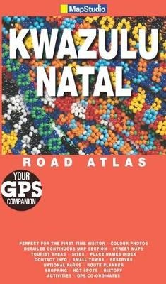
KwaZulu-Natal Road Atlas
2009
|
4th edition
Map Studio (Verlag)
978-1-77026-170-9 (ISBN)
Map Studio (Verlag)
978-1-77026-170-9 (ISBN)
- Titel ist leider vergriffen;
keine Neuauflage - Artikel merken
This revised and updated edition includes GPS co-ordinates and the new Durban street names. This tourist atlas provides detailed coverage of the entire KwaZulu-Natal province with main towns and tourist sites. It gives top travel tips and information on tourism resources. Coverage of the north coast includes Umhlanga, Ballito, Shaka's Rock, Salt Rock, Gingindlovu, Mtunzini and inland to Eshowe. The coverage of Zululand and surrounds includes Empangeni, Richards Bay, Ulundi, Melmoth, Zululand's Wildlife, St Lucia Wetland Reserve, Zululand parks and reserves, St Lucia, Sodwana, Kosi Bay and continues into Mozambique. The south coast coverage includes Amanzimtoti, Kingsburgh, Scottburgh, Hibberdene and Port Shepstone, Oribi Gorge, Margate, Uvongo, Uvongo River nature reserve, Ramsgate, Port Edward, Kokstad, Mount Currie nature reserve and Route 617. Coverage from Kloof to Mooi River features Valley of 1000 Hills, Pietermaritzburg, Howick and Midmar region, Howick, Albert Falls, Midlands Meander, Mooi River, Bushmans River region, Estcourt, Weenen nature reserve, Winterton, Bergville and Spioenkop Dam.
| Erscheint lt. Verlag | 1.12.2009 |
|---|---|
| Verlagsort | Cape Town |
| Sprache | englisch |
| Maße | 140 x 240 mm |
| Gewicht | 222 g |
| Themenwelt | Reisen ► Karten / Stadtpläne / Atlanten |
| ISBN-10 | 1-77026-170-2 / 1770261702 |
| ISBN-13 | 978-1-77026-170-9 / 9781770261709 |
| Zustand | Neuware |
| Haben Sie eine Frage zum Produkt? |
Mehr entdecken
aus dem Bereich
aus dem Bereich
Buch | Hardcover (2022)
Klett (Verlag)
30,95 €


