


Road Atlas Cape Town to Port Elizabeth
2010
Struik Publishers,South Africa (Verlag)
978-1-77026-219-5 (ISBN)
Struik Publishers,South Africa (Verlag)
978-1-77026-219-5 (ISBN)
- Titel ist leider vergriffen;
keine Neuauflage - Artikel merken
Covers the main coastal route of the Western Cape & garden route. Between Cape Town and East London. Tourist friendly information and contact details. Detailed 1 : 750 000 maps of the region. Tourism contact details and resources. Detailed index. Includes detailed street plans of Cape Town; Knysna; Port Elizabeth [Including Summerstrand]; East London; Mossel Bay; Stellenbosch; Franschhoek; Worcester; Struis Bay; Hermanus; Swellendam; Montagu; Cape Infanta; Hartenbos; Oudtshoorn; George; Wilderness; Sedgefield; St Francis Ba; Jeffrey's Bay; Kenton On Sea; Grahamstown; Port Alfred; Beacon Bay; Kei Mouth.
| Erscheint lt. Verlag | 1.5.2010 |
|---|---|
| Sprache | englisch |
| Maße | 210 x 297 mm |
| Gewicht | 210 g |
| Themenwelt | Reisen ► Karten / Stadtpläne / Atlanten ► Afrika |
| ISBN-10 | 1-77026-219-9 / 1770262199 |
| ISBN-13 | 978-1-77026-219-5 / 9781770262195 |
| Zustand | Neuware |
| Informationen gemäß Produktsicherheitsverordnung (GPSR) | |
| Haben Sie eine Frage zum Produkt? |
Mehr entdecken
aus dem Bereich
aus dem Bereich
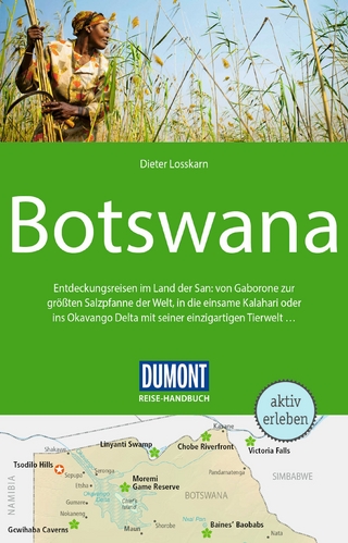
Entdeckungsreisen im Land der San: von Gaborone zur größten …
Buch | Softcover (2024)
DuMont Reiseverlag
24,95 €