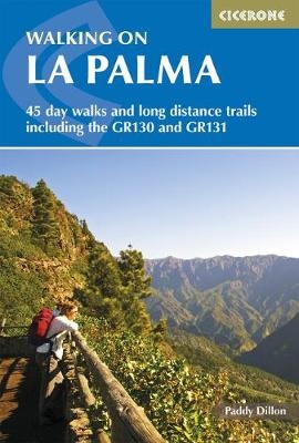
Walking on La Palma
Cicerone Press (Verlag)
978-1-85284-604-6 (ISBN)
- Titel ist leider vergriffen;
keine Neuauflage - Artikel merken
Guide to walking on La Palma. In total 45 day walks are described ranging from 8km to 32km in length, and covering a wide variety of terrain. Although La Palma is one of the smaller Canary Islands, there are routes of all types from easy strolls to hands-on scrambling, from simple day walks to long distance treks on rocky mountain paths, including the GR 130 which circumnavigates the island and the island-hopping GR 131.
The circular GR 130 trail takes about a week to complete and can be started and finished at any point around the island. The GR 131 trail is exclusively high-level and mountainous, requiring careful planning. The dramatic volcanic landscape of La Palma, reputed to be one of the steepest islands in the world, is little-known outside the Canaries, but offers an ideal winter walking destination for walkers of most abilities featuring rocky treks and mountain paths.
Includes lots of background information on geology, wildlife, plants and flowers as well as practical information on accommodation, currency and language.
Paddy Dillon is a prolific walker and writer, with over 40 books to his name, many published by Cicerone. He has contributed to many outdoor publications and appeared on radio and television. Living on the fringes of the English Lake District, Paddy has led guided walking holidays and walked throughout the UK and Europe, as well as in Nepal, Tibet, and the Rocky Mountains. He has also walked extensively throughout the Canaries.
Introduction
Location
Geology
Wildlife
National parks
The Fortunate Isles
Getting there
When to go
Accommodation
Health and safety
Food and drink
Language
Money
Communications
Walking on La Palma
Introduction
Getting there
Getting around
What to take
Waymarking and access
Maps
Food and drink
Tourist information offices
Emergencies
Using this guide
The Walks
1 Santa Cruz and Lomo de las Nieves
2 Fuentes de Las Breñas
3 Buenavista and Pico de las Ovejas
4 Santa Cruz and Montaña de Tagoja
5 Pico de la Nieve to Santa Cruz
6 Santa Cruz to Puerto de Tazacorte
7 El Paso to Refugio del Pilar
8 Refugio del Pilar to Santa Cruz
9 Refugio del Pilar to Playa del Hoyo
10 Refugio del Pilar to Playa del Hoyo or La Salemera
11 Refugio del Pilar and Pico Nambroque
12 Jedey to Tigalate
13 San Nicolás and Coladas de San Juan
14 Llanos del Jable and Coladas de San Juan
15 Pico Bejenado
16 La Cumbrecita to La Cancelita and Los Llanos
17 Barranco de las Angustias and Caldera de Taburiente
18 La Cumbrecita to Caldera de Taburiente
19 Caldera de Taburiente and Hoya Verde
20 Tijarafe and Porís de Candelaria
21 Tinizara to Piedras Altas and Tijarafe
22 La Traviesa: El Time to Briesta
23 La Traviesa: Briesta to Barlovento
24 La Zarza and Don Pedro
25 Roque del Faro to Garafía
26 Roque del Faro and Franceses
27 Roque del Faro to Roque de los Muchachos
28 Roque de los Muchachos to Puntagorda or Tijarafe
29 Pico de la Cruz to Barlovento
30 Pico de la Cruz to Los Sauces or Barlovento
31 Los Sauces and Los Tilos
32 Fuente de Olén to Las Lomadas
33 Fuente Vizcaína to La Galga
34 Pico de la Nieve to Puntallana or Tenagua
35 GR 130: Santa Cruz de La Palma to Mazo
36 GR 130: Mazo to Fuencaliente
37 GR 130: Fuencaliente to Los Llanos
38 GR 130: Los Llanos to Puntagorda
39 GR 130: Puntagorda to Garafía
40 GR 130: Garafía to Franceses
41 GR 130: Franceses to Los Sauces
42 GR 130: Los Sauces to Santa Cruz de La Palma
43 GR 131: Puerto de Tazacorte to Roque de los Muchachos
44 GR 131: Roque de los Muchachos to Refugio del Pinar
45 GR 131: Refugio del Pinar to Faro de Fuencaliente
Appendix A Route Summary Table
Appendix B Topographical Glossary
Appendix C Useful Contacts
| Erscheint lt. Verlag | 2.2.2017 |
|---|---|
| Zusatzinfo | 100 colour photos and 75 colour maps |
| Verlagsort | Kendal |
| Sprache | englisch |
| Maße | 116 x 172 mm |
| Gewicht | 270 g |
| Themenwelt | Sachbuch/Ratgeber ► Sport |
| Reiseführer ► Europa ► Spanien | |
| Reisen ► Reiseführer ► Welt / Arktis / Antarktis | |
| ISBN-10 | 1-85284-604-6 / 1852846046 |
| ISBN-13 | 978-1-85284-604-6 / 9781852846046 |
| Zustand | Neuware |
| Haben Sie eine Frage zum Produkt? |
aus dem Bereich


