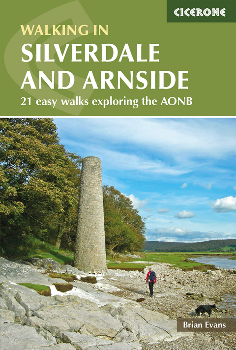
Walks in Silverdale and Arnside
Cicerone Press (Verlag)
978-1-85284-628-2 (ISBN)
A guidebook to 21 walks in the Silverdale and Arnside National Landscape, on the edge of Morecambe Bay, straddling the county boundary between Cumbria and Lancashire. The easy routes explore the area’s limestone crags, deer parks and beautiful coastline.
The walks range in length from 3 to 16km (2–10 miles) and can be enjoyed in 1–5 hours, perfect for either a short stroll or a longer day.
Clear step-by-step route description illustrated with sketch mapping
Sized to easily fit in a jacket pocket
Information on refreshments, parking and toilets for each walk
Local points of interest and historic buildings
Suggestions for longer linear routes
Brian Evans began walking in Silverdale with his parents in the 1940s, while living in nearby Morecambe. He has also trekked, climbed, skied, caved, canoed and, more recently, mountain biked all over the world but always enjoys returning to enjoy the landscapes and wildlife of Silverdale. He lives near Preston with his wife Aileen, his companion on most of the adventures.
Introduction
Geology
Industry through the ages
Wildlife
Walking seasons
Walking on the shore
Walking in the woods and hills
Rock climbing
Getting there
Using this guide
THE WALKS
Silverdale/Arnside area
Walk 1 South from Silverdale: Jack Scout, Jenny Brown's Point and Heald Brow
Walk 2 North from Silverdale: White Creek, Heathwaite and Arnside Tower
Walk 3 Crag Foot, Leighton Hall, Leighton Moss, Woodwell and Heald Brow
Walk 4 Warton Crag and the Three Brothers
Walk 5 The Pepperpot and Eaves Wood
Walk 6 Eaves Wood, Middlebarrow Quarry, Arnside Tower and the Pepperpot
Walk 7 Hawes Water and Gait Barrows NNR
Walk 8 Gait Barrows NNR, Hawes Water, Hazelslack and Leighton Beck
Walk 9 Cringlebarrow, Deepdale, Leighton Moss and Yealand Hall Allotment
Arnside
Walk 10 Around the shore: Arnside, Far Arnside and Arnside Knott
Walk 11 Arnside Knott from the Silverdale road
Walk 12 Arnside Moss, Hazelslack Tower, Fairy Steps and Sandside Cutting
Walk 13 Dallam Park, Beetham, Fairy Steps and Haverbrack Fell
Walk 14 Beetham, Hale Fell, Slack Head, Fairy Steps and Dallam Park
Farleton Knott, Holme Park Fell and Hutton Roof Crags
Walk 15 Farleton Knott and Holme Park Fell
Walk 16 Hutton Roof Crags
Walk 17 Clawthorpe Fell, Lancelot Clark Storth and Uberash Breast Cairns
Walk 18 Dalton Crags and Hutton Roof Crags
The Lancaster to Kendal Canal
Walk 19 Farleton Fell, Clawthorpe and the Lancaster Canal
Walk 20 Levens Park and the River Kent
Walk 21 Tewitfield Locks, Warton Crag, River Keer and the Lancaster Canal
APPENDIX A Route summary table
APPENDIX B Linear Walks
APPENDIX C Suggested Strolls
APPENDIX D The Cross Sands Walk
APPENDIX E Historic Buildings in the Area
APPENDIX F Recommended further reading
APPENDIX G Useful contacts
| Erscheint lt. Verlag | 3.12.2021 |
|---|---|
| Reihe/Serie | Cicerone guidebooks |
| Zusatzinfo | 65 colour photos, 15 maps and 6 author illustrations |
| Verlagsort | Kendal |
| Sprache | englisch |
| Maße | 116 x 172 mm |
| Gewicht | 180 g |
| Themenwelt | Sachbuch/Ratgeber ► Sport |
| Reiseführer ► Europa ► Großbritannien | |
| Reisen ► Sport- / Aktivreisen ► Europa | |
| ISBN-10 | 1-85284-628-3 / 1852846283 |
| ISBN-13 | 978-1-85284-628-2 / 9781852846282 |
| Zustand | Neuware |
| Haben Sie eine Frage zum Produkt? |
aus dem Bereich


