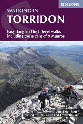
Walking in Torridon
Cicerone Press (Verlag)
978-1-85284-466-0 (ISBN)
A guidebook to the best walking routes in the mountains of Torridon in the western Highlands of Scotland. Based around Shieldaig and Slioch, the 52 day walks include easy walks to routes up Torridon's best summits, including 9 Munros.
This book makes Shieldaig its base and covers the 200 square miles south west of Loch Maree and north of the Achnasheen - Achnashellach - Lochcarron road, as well as Slioch and its environs. The guidebook offers a wealth of routes of different grades and differing characters between 2 and 14 miles in length. It is also beautifully illustrated with Peter Barton's original drawings, alongside clear OS map extracts. Routes described include 11 easy walks, 11 long or high-level walks, ascents of 32 summits over 2000ft and 5 outline suggestions for major ridge walks.
The mountains of Torridon rarely have clearly defined paths to their summits, but the many excellent stalkers' paths take walkers deep into wild territory and often give them a flying start. To explore this remote and much-loved area of the Highlands fully you need to be prepared to free-range over heather, grass, rock and marsh and this guide will help you find the best ways across the landscape.
Peter Barton produced this much-loved guide in 1989, after retiring to Torridon following a career in surgery. The guide has been revised and updated, in keeping with Peter's original style, by Chris Lowe, an author of wildlife guides to the region, with Jim Sutherland, local guide.
Overview map
Editor's Preface to the New Edition
Introduction - Peter Barton
Geology and vegetation - Chris Lowe
Easy Walks
EW1 The Falls of Balgy and Loch Damh (Shieldaig)
EW2 The Shieldaig Peninsula (Shieldaig)
EW3 West Lodge, Loch Torridon and Loch Torridon Hotel (Shieldaig)
EW4 Coire Mhic Nobuil (Alligin)
EW5 Ardheslaig to Kenmore (Applecross Peninsula)
EW6 Coulin Estate: Loch Clair and Loch Coulin (Glen Torridon)
EW7 Torridon (Fasag) to Inveralligin (north shore Upper Loch Torridon)
EW8 Heights of Kinlochewe (Incheril)
EW9 Toscaig to Airigh-drishaig (southern Applecross)
EW10 The Coire an Laoigh of Beinn Eighe (Glen Torridon)
EW11 The Cold Hollow of Fuar Tholl (from Achnashellach)
Long and High Level Walks
W1 Coire Mhic Fhearchair (ascent of Beinn Eighe)
W2 Walk round Beinn Alligin
W3 An Staonach-An Fur Ridge
W4 The Great Corries of Beinn Bhan
W5 Walk round Beinn na h-Eaglaise
W6 Walk to Applecross or around Croic Bheinn
W7 Heights of Kinlochewe and Gleann Bianasdail
W8 An Sgurr (Kishorn)
W9 Seana Mheallan (Glen Torridon)
W10 Three Flowerdale Miniatures: Meall a' Ghlas Leothaid, Meall na Meine and Meall Lochan a' Chleirich
W11 Through Walks
Mountain Ascents over 2000ft
Introduction
Liathach
Beinn Eighe
Northern Group
N1 Beinn Alligin
N2 An Ruadh Mheallan
N3 Beinn Bhreac
N4 Slioch
N5 Beinn a' Chearcaill
N6 Beinn an Eoin
N7 Baosbheinn
N8 Beinn Dearg
N9. Meall a' Ghuibhais (mountain trail)
Southern Group
S1 Beinn Damh
S2 Beinn Liath Mhor
S3 Sgorr nan Lochan Uaine
S4 Beinn Liath Bheag
S5 Sgurr Dubh
S6 Beinn na h-Eaglaise
S7 Beinn Shieldaig
S8 Beinn Bhan
S9 Sgurr a' Gharaidh
S10 Glas Bheinn
S11 Sgorr Ruadh
S12 Fuar Tholl
S13 Maol Chean Dearg
S14 Meall nan Ceapairean
S15 Meall Dearg
S16 Beinn a' Chlachain
S17 An Ruadh Stac
S18 Sgurr a' Chaorachain
S19 Meall Gorm
S20 Carn Breac
S21 Beinn na Feusaige
Major Ridge Walks
Appendix 1 Deer Stalking
Appendix 2 Useful Information
| Erscheint lt. Verlag | 19.2.2019 |
|---|---|
| Überarbeitung | Jim Sutherland, Chris Lowe |
| Zusatzinfo | 65 line drawings, 42 route maps and over 50 colour photos |
| Verlagsort | Kendal |
| Sprache | englisch |
| Maße | 116 x 172 mm |
| Gewicht | 280 g |
| Themenwelt | Sachbuch/Ratgeber ► Sport |
| Reiseführer ► Europa ► Großbritannien | |
| Reiseführer ► Europa ► Schottland | |
| ISBN-10 | 1-85284-466-3 / 1852844663 |
| ISBN-13 | 978-1-85284-466-0 / 9781852844660 |
| Zustand | Neuware |
| Informationen gemäß Produktsicherheitsverordnung (GPSR) | |
| Haben Sie eine Frage zum Produkt? |
aus dem Bereich


