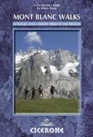
Mont Blanc Walks
Cicerone Press (Verlag)
978-1-85284-597-1 (ISBN)
- Titel ist leider vergriffen;
keine Neuauflage - Artikel merken
A guide to the best walking routes on both sides of Mont Blanc, in France and Italy, based around Chamonix and Courmayeur. 50 day walks are described and the guide outlines 4 multi-day treks around two sides of the Mont Blanc massif; Chamonix and Courmayeur. The day walks range from 2 to 12 miles and are organised by base and include both high-level and easy valley walks. In addition to the high-level walks there is often a valley walk that can be done whatever the weather, on tired days, with children, by bike, or as a run. The four multi-day treks that are briefly detailed all use parts of other walks already described in the guidebook and with a little imagination many more can be invented. The trek descriptions given are short, with just map information, daily altitude gain, distance and route details. These are not intended to be full guides to the routes, rather a basic outline to be used in conjunction with the appropriate maps.
Hilary Sharp is British and a qualified Accompagnateur en Montagne. She is also author of three other popular Cicerone guides - 'Snowshoeing in the Western Alps', 'Tour of the Matterhorn' and 'Tour of Monte Rosa' and runs her own trekking business from her home in the French Alps.
Introduction
The Region
How it all Started
Glaciers
Via Ferratas
Animals and Birds
Flowers and Trees
Transhumance and Alpages
When to Go
Getting There
Alpine Accommodation
Language
Currency
Maps
Safety
Security and Rescue
Guided Walking
Walking with Dogs
Mountain Biking
Trail Running
Things not to be Missed
How to Use this Guide
THE WALKS
Chapter 1 - St Gervais Les Bains and Les Contamines-Montjoie
1 Mont Truc
2 Mont Joly
3 Lac d'Armancette
4 Col de la Fenêtre
5 Tête Nord des Fours
6 Lacs and Monts Jovet
Chapter 2 - Servoz and the Plateau d'Assy
7 Lac Vert
8 Pointe Noire de Pormenaz
9 The Dérochoir and the Désert de Platé
Chapter 3 - Les Houches
10 Le Prarion
11 Mont Vorassay
12 Aiguillette des Houches
Chapter 4 - Chamonix
13 Chamonix Valley Walk
14 La Chapeau and Tête des Prapators
15 Montenvers
16 Montagne de Blaitière
17 Chalet de Cerro
18 Montagne de la Côte
19 Refuge de Bel Lachat and Le Brévent
20 Grand Balcon Sud - La Flégère to Planpraz
21 Lac Blanc
22 Tête de Villy
23 Col de Salenton
24 Lac Cornu and Lacs Noirs
Chapter 5 - Argentière
25 Argentière Valley Walk
26 Pierre à Bosson
27 Tête du Grand Chantet
28 Aiguillette d'Argentière - Les Chéserys
29 Argentière Glacier Pointe de Vue
30 Aiguillette des Posettes
31 Refuge Albert Premier
32 Croix de Fer
Chapter 6 - Vallorcine
33 Vallorcine Valley Walk
34 Pointe de la Terrasse and Tré-les-Eaux Valley
35 Cheval Blanc
36 Dinosaur Tracks
37 Bel Oiseau
38 Col de Barberine and Fontanabran
39 Refuge de la Pierre à Bérard
40 Mont Buet by the Normal Route
41 Refuge de Loriaz
42 Emosson from Loriaz
43 Mont Buet by the north ridge
Chapter 7 - Courmayeur
44 Punta della Croce
45 Mont Fortin
46 Mont Chétif
47 Col and Lac Liconi
48 Mont de la Saxe
49 Tête Entre Deux Sauts
50 Tête de Ferret
Chapter 8 - Multi-day Treks
51 Vallorcine to Plaine Joux
52 Tour of the Aiguilles Rouges
53 Vallorcine to Servoz
54 Italian Val Ferret Circuit
APPENDIX 1 Mont Blanc Region Tourist Offices
APPENDIX 2 Useful Terms and Glossary
APPENDIX 3 Transport in the Chamonix and Courmayeur Valleys
APPENDIX 4 Rainy Day/Rest Day Activities
APPENDIX 5 Hut Etiquette
APPENDIX 6 Climbing Peaks and Hiring Guides
| Erscheint lt. Verlag | 18.9.2012 |
|---|---|
| Zusatzinfo | Over 60 colour maps and 100 colour photos |
| Verlagsort | Kendal |
| Sprache | englisch |
| Maße | 116 x 172 mm |
| Gewicht | 350 g |
| Themenwelt | Sachbuch/Ratgeber ► Sport |
| Reiseführer ► Europa ► Frankreich | |
| ISBN-10 | 1-85284-597-X / 185284597X |
| ISBN-13 | 978-1-85284-597-1 / 9781852845971 |
| Zustand | Neuware |
| Haben Sie eine Frage zum Produkt? |
aus dem Bereich


