


New Zealand Travel Map
Fourth Edition
2010
|
3rd Revised edition
Periplus Editions (Verlag)
978-0-7946-0541-4 (ISBN)
Periplus Editions (Verlag)
978-0-7946-0541-4 (ISBN)
- Titel erscheint in neuer Auflage
- Artikel merken
Zu diesem Artikel existiert eine Nachauflage
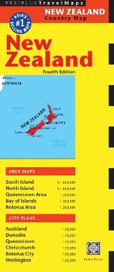
A brand new edition utilising the latest survey information and featuring detailed, fully indexed area maps of South and North Islands, Queenstown area, Bay of Islands and Rotorua area to an overall scale of 1:1 600 000, along with detailed city plans.
A brand new edition utilising the latest survey information and featuring detailed, fully indexed area maps of South and North Islands, Queenstown area, Bay of Islands and Rotorua area to an overall scale of 1:1 600 000. There are also detailed city plans of Auckland, Dunedin, Christchurch, Queenstown, Rotorua City and Wellington. The mapping is accompanied by essential travel tips to help your trip go smoothly and the unique folding system allows the user to view one panel at a time, making it extremely easy to use on the move.
A brand new edition utilising the latest survey information and featuring detailed, fully indexed area maps of South and North Islands, Queenstown area, Bay of Islands and Rotorua area to an overall scale of 1:1 600 000. There are also detailed city plans of Auckland, Dunedin, Christchurch, Queenstown, Rotorua City and Wellington. The mapping is accompanied by essential travel tips to help your trip go smoothly and the unique folding system allows the user to view one panel at a time, making it extremely easy to use on the move.
| Erscheint lt. Verlag | 12.5.2010 |
|---|---|
| Reihe/Serie | Periplus Maps |
| Zusatzinfo | 5 Area Maps, 6 City Plans |
| Verlagsort | Boston |
| Sprache | englisch |
| Maße | 260 x 108 mm |
| Gewicht | 68 g |
| Themenwelt | Reisen ► Karten / Stadtpläne / Atlanten ► Australien / Neuseeland / Ozeanien |
| ISBN-10 | 0-7946-0541-9 / 0794605419 |
| ISBN-13 | 978-0-7946-0541-4 / 9780794605414 |
| Zustand | Neuware |
| Informationen gemäß Produktsicherheitsverordnung (GPSR) | |
| Haben Sie eine Frage zum Produkt? |
Mehr entdecken
aus dem Bereich


aus dem Bereich
Inkl. Stadtpläne, Ortsverzeichnis und Reiseinformationen
Karte (gefalzt) (2024)
Hallwag (Verlag)
12,95 €
Karte/Kartografie (2023)
MAIRDUMONT (Verlag)
11,95 €
Karte (gefalzt) (2024)
Lonely Planet Global Limited (Verlag)
7,45 €