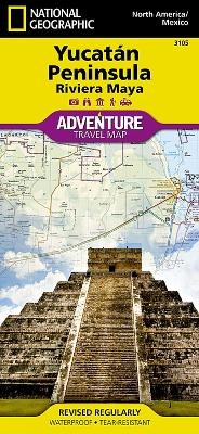
Northern Yucatn/maya Sites, Mexico
Travel Maps International Adventure Map
Seiten
2012
National Geographic Maps (Verlag)
978-1-56695-245-3 (ISBN)
National Geographic Maps (Verlag)
978-1-56695-245-3 (ISBN)
AdventureMaps provide global travellers with the perfect combination of detail and perspective. The Northern Yucatn Peninsula and Maya Sites map provides unmatched detail and information for the highly popular Yucatn Peninsula and its important Maya archaeological sites. Detailed city inset maps of Cancn and Mrida provide locations of attractions and key infrastructure. Detailed descriptions, photographs, and site maps on the reverse guide the traveller through important Maya buildings and history, such as Chichn Itz, Ek Balam, Tulum, El Rey, Uxmal, Cob, & San Gervasiolo
Founded in 1915 as the Cartographic Group, the first division of the National Geographic Society, National Geographic Maps has been responsible for illustrating the world around us through the art and science of mapmaking. Today, National Geographic Maps continues this mission by creating the world's best wall maps, recreation maps, atlases, and globes which inspire people to care about and explore their world. All proceeds from the sale of National Geographic maps go to support the Society's non-profit mission to increase global understanding and promote conservation of our planet through exploration, research, and education.
| Erscheint lt. Verlag | 2.8.2012 |
|---|---|
| Reihe/Serie | National Geographic Adventure Maps |
| Verlagsort | Evergreen |
| Sprache | englisch |
| Maße | 108 x 235 mm |
| Gewicht | 96 g |
| Einbandart | gefalzt |
| Themenwelt | Reisen ► Karten / Stadtpläne / Atlanten ► Nord- / Mittelamerika |
| ISBN-10 | 1-56695-245-X / 156695245X |
| ISBN-13 | 978-1-56695-245-3 / 9781566952453 |
| Zustand | Neuware |
| Haben Sie eine Frage zum Produkt? |
Mehr entdecken
aus dem Bereich
aus dem Bereich
Karte (gefalzt) (2024)
Freytag-Berndt und ARTARIA (Verlag)
12,90 €
Karte (gefalzt) (2023)
Reise Know-How (Verlag)
12,00 €
Karte (gefalzt) (2023)
Reise Know-How (Verlag)
12,00 €


