


Madeira Tour and Trail Map Super-durable Version
2009
|
6th Revised edition
Discovery Walking Guides Ltd (Verlag)
978-1-904946-57-1 (ISBN)
Discovery Walking Guides Ltd (Verlag)
978-1-904946-57-1 (ISBN)
- Titel erscheint in neuer Auflage
- Artikel merken
Zu diesem Artikel existiert eine Nachauflage
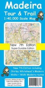
Thanks to all the walking research and road surveys carried out by Shirley and Mike Whitehead for the new Walk! Madeira we have been able to comprehensively update our digital database to produce a new 6th Edition. Significant changes include the new road system around Cabo Girau, a new 'roads in construction' layer showing proposed road developments, new road numbering system, plus the hundreds of updates to walking trails and dirt roads surveyed during Shirley and Mike's research. Scale 1:40,000 2.5cms = 1km. Total printed Map area 152 cms by 60 cms. Map size double-sided 84 cm by 60 cm folded to 23cm by 12cm. Roads; Motorway (Via Rapida), major roads, secondary roads, minor roads & tarmacked lanes up-to-date at June 2009 for all the new roads and tunnels; including the new road numbering system. Tracks & Trails; Unsurfaced (dirt) roads and walking trails. Heights; 100 & 50 metre contours, height & trig points in metres, height background colours in 200 metre colour bands. Grid; 1 minute Latitude Longitude grid with WGS84 Datum. Published Walking Routes; 'red dashed line' walking routes 'tracked' onto the map from new Walk!
Madeira while Shirley Whitehead's Madeira Walks and other published walking routes are shown in 'green dashed line'. Madeira Tour & Trail Map 6th Edition has been produced in 'Map-Paper' and 'Super-Durable' versions. If you are just planning a one-off trip to Madeira you might want to save GBP3 by buying the 'Map-Paper' version. Is it worth paying GBP8.99 for the Super-Durable version? Yes, it is. You get the best Madeira map that is waterproof, feels like silk but has incredible strength that will survive rough use for years to come - invest in the best. Still not convinced? Just ask anyone who has used a DWG Super-Durable Map, they'll soon tell you the advantages.
Madeira while Shirley Whitehead's Madeira Walks and other published walking routes are shown in 'green dashed line'. Madeira Tour & Trail Map 6th Edition has been produced in 'Map-Paper' and 'Super-Durable' versions. If you are just planning a one-off trip to Madeira you might want to save GBP3 by buying the 'Map-Paper' version. Is it worth paying GBP8.99 for the Super-Durable version? Yes, it is. You get the best Madeira map that is waterproof, feels like silk but has incredible strength that will survive rough use for years to come - invest in the best. Still not convinced? Just ask anyone who has used a DWG Super-Durable Map, they'll soon tell you the advantages.
| Erscheint lt. Verlag | 30.5.2009 |
|---|---|
| Reihe/Serie | Tour & Trail Maps |
| Zusatzinfo | Topographical map at 1:40,000 scale |
| Verlagsort | Northampton |
| Sprache | englisch |
| Maße | 120 x 235 mm |
| Themenwelt | Reisen ► Karten / Stadtpläne / Atlanten ► Welt / Arktis / Antarktis |
| ISBN-10 | 1-904946-57-7 / 1904946577 |
| ISBN-13 | 978-1-904946-57-1 / 9781904946571 |
| Zustand | Neuware |
| Haben Sie eine Frage zum Produkt? |
Mehr entdecken
aus dem Bereich

aus dem Bereich
1:30 Mio. mit Posterleisten, mit Oberflächenlaminat
Karte (gerollt) (2023)
INTERKART Landkarten & Globen (Verlag)
25,90 €