Ireland North Raised Relief Map
Dark Wood Frame
2008
Dorrigo (Verlag)
978-1-906473-27-3 (ISBN)
Dorrigo (Verlag)
978-1-906473-27-3 (ISBN)
- Keine Verlagsinformationen verfügbar
- Artikel merken
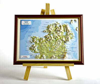
Ready to be wall mounted, the mapping scale of this map is 1:1400,000. Offering rivers, roads, contours and spot heights, it covers the area from Giants Causeway to Wicklow.
Dorrigo raised relief maps are available framed in choice of dark or light solid wood moulding styles or without a frame for customers to choose a finish of their own. They are ready to be wall mounted. The mapping is very accurate at a scale of 1:1400,000 and offers a unique presentation of rivers, roads, contours and spot heights. Finished size is 220x300mm. Area coverage of this map is from Giants Causeway to Wicklow.
Dorrigo raised relief maps are available framed in choice of dark or light solid wood moulding styles or without a frame for customers to choose a finish of their own. They are ready to be wall mounted. The mapping is very accurate at a scale of 1:1400,000 and offers a unique presentation of rivers, roads, contours and spot heights. Finished size is 220x300mm. Area coverage of this map is from Giants Causeway to Wicklow.
| Reihe/Serie | Raised Relief Maps Series |
|---|---|
| Zusatzinfo | colour illustrations |
| Verlagsort | Manchester |
| Sprache | englisch |
| Maße | 335 x 255 mm |
| Themenwelt | Naturwissenschaften ► Geowissenschaften ► Geografie / Kartografie |
| ISBN-10 | 1-906473-27-7 / 1906473277 |
| ISBN-13 | 978-1-906473-27-3 / 9781906473273 |
| Zustand | Neuware |
| Haben Sie eine Frage zum Produkt? |
Mehr entdecken
aus dem Bereich
aus dem Bereich
Karte (gerollt) (2024)
Freytag-Berndt und ARTARIA (Verlag)
19,90 €


