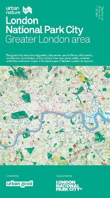
London National Park City map
Greater London area
Seiten
2021
Urban Good (Verlag)
978-1-914432-00-2 (ISBN)
Urban Good (Verlag)
978-1-914432-00-2 (ISBN)
The massive map includes all of the parks, woodlands, playing fields, nature reserves, city farms, rivers, canals, and all the spaces that contribute to London’s parkland. Some of the most iconic walks through and around London are drawn along with symbols marking places to swim outdoors, climb peaks, pitch a tent or go kayaking.
It shows London as the world’s first National Park City. The massive map includes all of the parks, woodlands, playing fields, nature reserves, city farms, rivers, canals and all the spaces that contribute to London’s parkland. Some of the most iconic walks through and around London are drawn, such as the London Loop and Capital Ring, along with symbols marking places to swim outdoors, climb peaks, pitch a tent or go kayaking.
Connecting children and adults to nature, experiencing the benefits of green and blue space, finding play spaces and sports pitches, seeking out new trails, cycle paths, learning about biodiversity and where to look for all the above is why we made this map.
The Urban Nature Maps aim to stimulate us to see the city differently and to explore its open spaces. It's a resource to encourage more awareness and more action for people and nature... to help put nearby nature in everyday lives. The numerous walking routes prove extremely popular with users. Furthermore, the maps are part of a great campaign to make London 'greener, healthier and wilder' as the world's first National Park City.
Urban Good CIC is a social enterpirse that makes maps for people to explore their nearby nature, founded by Charlie Peel in 2017.
| Erscheint lt. Verlag | 9.12.2021 |
|---|---|
| Reihe/Serie | Urban Nature Maps |
| Mitarbeit |
Karten von: Charlie Peel |
| Zusatzinfo | 1 Illustrations, unspecified |
| Sprache | englisch |
| Maße | 1270 x 952 mm |
| Themenwelt | Reisen ► Karten / Stadtpläne / Atlanten ► Europa |
| Naturwissenschaften ► Geowissenschaften ► Geografie / Kartografie | |
| ISBN-10 | 1-914432-00-2 / 1914432002 |
| ISBN-13 | 978-1-914432-00-2 / 9781914432002 |
| Zustand | Neuware |
| Haben Sie eine Frage zum Produkt? |
Mehr entdecken
aus dem Bereich
aus dem Bereich
Straßen- und Freizeitkarte 1:250.000
Karte (gefalzt) (2023)
Freytag-Berndt und ARTARIA (Verlag)
12,90 €
Karte (gefalzt) (2023)
Freytag-Berndt und ARTARIA (Verlag)
12,90 €
Östersund
Karte (gefalzt) (2023)
Freytag-Berndt und ARTARIA (Verlag)
12,90 €


