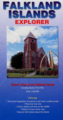
Falkland Islands Explorer
Visitors Map of the Falklands Islands Including Stanley Town Plan
2002
Ocean Explorer Maps (Verlag)
978-0-9538618-8-0 (ISBN)
Ocean Explorer Maps (Verlag)
978-0-9538618-8-0 (ISBN)
- Titel erscheint in neuer Auflage
- Artikel merken
Zu diesem Artikel existiert eine Nachauflage
A map which covers the Falkland Islands region with key areas identified. It also presents information of the area's wildlife, geography and history, along with providing a town plan to Stanley.
Fine map in the excellent "Ocean Explorer" series covering the Falkland Islands region. Produced in the same format as the previous maps in the series, one side provides a detailed map of the islands with key areas identified, while the other side presents information of the area's wildlife, geography and history, along with providing a town plan to Stanley.
Fine map in the excellent "Ocean Explorer" series covering the Falkland Islands region. Produced in the same format as the previous maps in the series, one side provides a detailed map of the islands with key areas identified, while the other side presents information of the area's wildlife, geography and history, along with providing a town plan to Stanley.
| Reihe/Serie | Ocean Explorer Maps |
|---|---|
| Zusatzinfo | Col & b/w photos, Scale: 1:365,000 |
| Verlagsort | Chichester |
| Sprache | englisch |
| Maße | 170 x 240 mm |
| Themenwelt | Reisen ► Karten / Stadtpläne / Atlanten ► Welt / Arktis / Antarktis |
| Naturwissenschaften ► Geowissenschaften ► Geografie / Kartografie | |
| ISBN-10 | 0-9538618-8-0 / 0953861880 |
| ISBN-13 | 978-0-9538618-8-0 / 9780953861880 |
| Zustand | Neuware |
| Haben Sie eine Frage zum Produkt? |
Mehr entdecken
aus dem Bereich
aus dem Bereich
1:30 Mio. mit Posterleisten, mit Oberflächenlaminat
Karte (gerollt) (2023)
INTERKART Landkarten & Globen (Verlag)
25,90 €


