Philip's Europe Wall Map
1999
Philip's (Verlag)
978-0-540-07775-5 (ISBN)
Philip's (Verlag)
978-0-540-07775-5 (ISBN)
- Titel ist leider vergriffen;
keine Neuauflage - Artikel merken
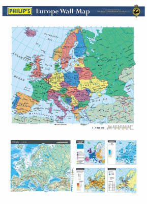
This map presents a political landscape of Europe and is created from digital cartography. Smaller maps underneath detail topics such as the European Union, rainfall, population and transport. It details both physical and political features.
| Verlagsort | London |
|---|---|
| Sprache | englisch |
| Maße | 980 x 680 mm |
| Gewicht | 155 g |
| Themenwelt | Schulbuch / Wörterbuch |
| Naturwissenschaften ► Geowissenschaften ► Geografie / Kartografie | |
| ISBN-10 | 0-540-07775-5 / 0540077755 |
| ISBN-13 | 978-0-540-07775-5 / 9780540077755 |
| Zustand | Neuware |
| Haben Sie eine Frage zum Produkt? |
Mehr entdecken
aus dem Bereich
aus dem Bereich
Karte (gerollt) (2024)
Freytag-Berndt und ARTARIA (Verlag)
19,90 €


