Deepmaps Central Lake District 3D Terrain Map
2012
DeepMaps (Verlag)
978-0-9571164-0-5 (ISBN)
DeepMaps (Verlag)
978-0-9571164-0-5 (ISBN)
- Titel ist leider vergriffen;
keine Neuauflage - Artikel merken
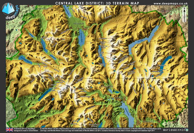
A map of the Central Lake District that allows the viewer to instantly see the Lake District terrain in 3D without any glasses or other equipment. It gives viewers an understanding of the landscape topography, and aids route planning for walkers and other outdoor enthusiasts.
This Deepmap of the Central Lake District allows the viewer to instantly see the Lake District terrain in 3D without any glasses or other equipment. It is designed to give viewers an understanding of the landscape topography which traditional maps rarely offer, and will aid route planning for walkers and other outdoor enthusiasts. The map appears as solid 3D, like a model, but is actually flat. It uses cutting edge printing technology to show slightly different views of the same terrain to each eye. This 3D is superior to mass-market 3D, as seen in televisions, because instead of just 2 images, there are 19 images. When the viewer moves their head to a different viewpoint, they get a different view as if looking around the terrain model, and a seamless impression of depth. No glasses are needed - thousands of tiny lenses built into the surface of the map create the 3D effect. The map, which is slightly larger than A3 size, shows the central portion of the Lake District National Park in Cumbria, from Skiddaw in the North to the Old Man of Coniston in the South. Approximately fifty of the tallest Lakeland fells are labelled, along with major settlements and the larger lakes.
Contour lines and grid lines are overlaid onto the model, giving an unusual and useful combination of cartographic notation and real depth. Deepmaps are printed on durable polyester resin plastic with a protective polypropylene backing to the print layer. They are tough, waterproof and require no power, equipment or special lighting to be viewed.
| Erscheint lt. Verlag | 1.1.2012 |
|---|---|
| Zusatzinfo | colour, solid 3D illustrations |
| Verlagsort | Cupar |
| Sprache | englisch |
| Maße | 450 x 310 mm |
| Themenwelt | Naturwissenschaften ► Geowissenschaften ► Geografie / Kartografie |
| ISBN-10 | 0-9571164-0-3 / 0957116403 |
| ISBN-13 | 978-0-9571164-0-5 / 9780957116405 |
| Zustand | Neuware |
| Haben Sie eine Frage zum Produkt? |
Mehr entdecken
aus dem Bereich
aus dem Bereich
Karte (gerollt) (2024)
Freytag-Berndt und ARTARIA (Verlag)
19,90 €


