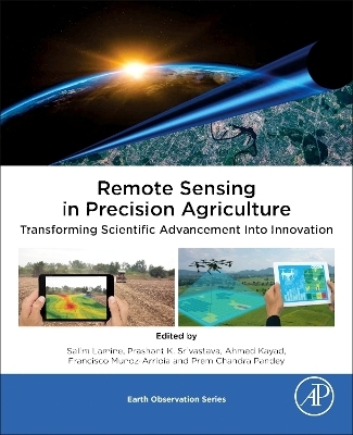
Remote Sensing in Precision Agriculture
Academic Press Inc (Verlag)
978-0-323-91068-2 (ISBN)
Salim Lamine is a distinguished scientist, serving as a professor and international consultant specializing in remote sensing and precision agriculture. He earned his PhD through a collaborative program between Aberystwyth University in the United Kingdom and the University of Sciences and Technology Houari Boumediene in Algeria. His academic pursuits further extended to the University of Nottingham in the UK, where he delved into GNSS applications, and he gained valuable research experience as an assistant researcher at the University of Aberystwyth. In 2017 Dr. Lamine was honored with the prestigious International Prize for the Environment, “ECOWORLD, by the Russian Academy of Natural Sciences. He holds mas ter’s degrees from both the Mediterranean Agronomic Institute of Bari in Italy and the Mediterranean Agronomic Institute of Chania in Greece. Currently, he is serving as a member of the editorial board for the prominent Taylor & Francis journal, Geocarto International. Additionally, he extends his expertise as a valued member of the Advisory Panel for several MDPI Journals. Dr. Lamine’s research portfolio encompasses a wide range of multidisciplinary areas, including remote sensing, precision agriculture, hyperspectral imaging, drone-based data analysis, crop yield prediction, field spectroradiometry, water and soil management, agri-biosystems engineering, gis and space mapping, machine learning and SVAT models. Dr. Lamine has made substantial contribu tions to the academic realm, evidenced by over 30 peer-reviewed publications in esteemed journals and participation in more than 150 international confer ences. His scholarly influence also extends to the authorship of several book chapters. He authored a book entitled REMOTE SENSING: Multispectral & Hyperspectral Applications published in 2020. Prashant K. Srivastava is working at IESD, Banaras Hindu University, as a faculty and was affiliated with Hydrological Sciences, NASA Goddard Space Flight Center, as research scientist on SMAP satellite soil mois ture retrieval algorithm development, instrumentation, and simulation for various applications. He received his PhD degree from the Department of Civil Engineering, University of Bristol, Bristol, United Kingdom. Prashant was the recipient of several awards such as NASA Fellowship, USA; University of Maryland Fellowship, USA; Commonwealth Fellowship, UK; Early Career Research Award (ECRA, DST, India), CSIR, as well as UGC JRF-NET (2005, 2006). He is leading a number of projects funded from reputed agencies in India as well as world. He was also a collaborator with NASA JPL on SMAP soil mois ture calibration and validation as well as Scatsat-1, NISAR, AVIRIS-NG missions of India. Prashant made more than 200+ publications in peer-reviewed journals and published 14 books with reputed publishing house such as Springer, Taylor and Francis, AGU-Wiley, and Elsevier, and several book chapters with good cita tion index. He presented his work in several conferences and workshops and is acting as a convener for the last few years in EGU, Hydroinformatics (HIC), and other conferences. He is also acting as Regional Editor Asia-Geocarto International (T & F), Associate Editor-Journal of Hydrology (Elsevier), GIScience and Remote Sensing (T & F), Remote Sensing Applications: Society and Environment (Elsevier), Sustainable Environment (T & F), Water Resources Management (Springer), Frontiers Remote Sensing, Associate Editor- Remote Sensing-MDPI, Associate Editor- Environment, Development and Sustainability (Springer), Environmental Processes (Springer), Bull of Env and Sci Res. Ahmed Kayad is an agricultural engineer advisor for applied research and extension at the University of California, Agriculture & Natural Resources (UC ANR), United States. He holds a PhD in environment resources?digital agriculture from the University of Padova in Italy, awarded in 2021. His academic journey began with a BSc in agricultural engineering from Alexandria University, Egypt, followed by an MSc from King Saud University, Saudi Arabia. Ahmed’s career has encompassed various roles, including serving as a farm machinery engineer at CLAAS agent in Egypt from 2010 to 2011, conducting research at the Precision Agriculture Research Chair (PARC) at King Saud University, Saudi Arabia from 2011 to 2018, and pursuing doctoral and postdoctoral research at the Digital Agriculture Lab, University of Padua, Italy, from 2018 to 2022. Additionally, he was a visiting doctoral researcher at the International Maize and Wheat Improvement Center (CIMMYT), Mexico, in 2020, and pursued postdoctoral studies at the University of California, Riverside, United States, from 2022 to 2023. Ahmed published several articles in scientific journals and international conferences, primarily focusing on remote sensing in agriculture, precision agriculture, and digital agri?culture. His expertise extends to serving as an expert reviewer for prestigious funding agencies in Europe and the United States, particularly in projects related to digital and precision agriculture. Ahmed’s research is centered on crop yield monitoring, weed detection, farm machinery, and the application of drones and sensors in agriculture. Francisco Mun˜oz-Arriola is an associate professor in hydroinformatics and integrated hydroclimate at the University of Nebraska-Lincoln and adjunct faculty in the Department of Biosystems Engineering at Universidade do Sao Paulo. Francisco has been a volunteer for science at the US Geological Survey and national researcher at Mexico’s National Council of Science and Technology. He is also a fellow of the Robert B. Daugherty Water for Food Global Institute and the Public Policy Center. He has been a member of the American Meteorological Society’s Water Resources Committee for 5 years. Francisco has worked on the diagnostics and predictability of natural and altered states of biogeochemical cycles and the water continuum from the atmosphere to the aquifer. His research focuses on the predictability of hydrometeorological and climate extremes and their impact on water and agricultural resources, the devel?opment of information technologies and models. His collaborative network encompasses more than 20 countries in Asia, Europe, and the United States Dr. Prem Chandra Pandey received PhD from the University of Leicester, United Kingdom, under Commonwealth Scholarship and Fellowship Plan. Currently, he is working as an assistant professor at the Department of Life Sciences, School of Natural Sciences, Shiv Nadar Institution of Eminence (Deemed to be University), UP, India. Previously, he has been associated with Banaras Hindu University, India, as an SERB-NPDF fellow. He received BSc and MSc degrees from Banaras Hindu University and MTech degree (Remote Sensing) from Birla Institute of Technology, India. He has worked as a professional research fellow on remote sensing applica tions in the National Urban Information System funded by NRSC Government of India. He has been a recipient of several awards including Commonwealth Fellow, United Kingdom, INSPIRE fellow GoI, MHRD-UGC fellow GoI, Malviya Gold Medal from Banaras Hindu University, SERB-NPDF from Government of India, and Young Investigator Award. Dr. Pandey is working in three projects related to monitoring of wetlands/Chilika lake mainly focusing on Ramsar sites along with other natural resources based research work funded by NGP and SERB Government of India. He has published more than 50 peer reviewed journal papers, seven edited books, several book chapters, and presented his work in national and international conferences. He is serving as a member of editorial board for Geocarto International journal, Taylor & Francis, Sustainable Development (Wiley- IF 12.5) and acted as a guest editor for Remote Sensing,
Section 1. Introduction and Principles of Precision Agriculture
Section 2. PA Practices for soil management
Section 3. PA practices for irrigation water management
Section 4. PA practices for crop management
Section 5. Advanced modelling practices in PA
Section 6. Future Aspects and Challenges in RS for PA
| Erscheinungsdatum | 28.10.2023 |
|---|---|
| Reihe/Serie | Earth Observation |
| Zusatzinfo | 230 illustrations (184 in full color); Illustrations |
| Verlagsort | Oxford |
| Sprache | englisch |
| Maße | 191 x 235 mm |
| Gewicht | 1000 g |
| Themenwelt | Mathematik / Informatik ► Informatik |
| Naturwissenschaften ► Biologie ► Ökologie / Naturschutz | |
| Naturwissenschaften ► Geowissenschaften ► Geografie / Kartografie | |
| Technik | |
| Weitere Fachgebiete ► Land- / Forstwirtschaft / Fischerei | |
| ISBN-10 | 0-323-91068-8 / 0323910688 |
| ISBN-13 | 978-0-323-91068-2 / 9780323910682 |
| Zustand | Neuware |
| Informationen gemäß Produktsicherheitsverordnung (GPSR) | |
| Haben Sie eine Frage zum Produkt? |
aus dem Bereich


