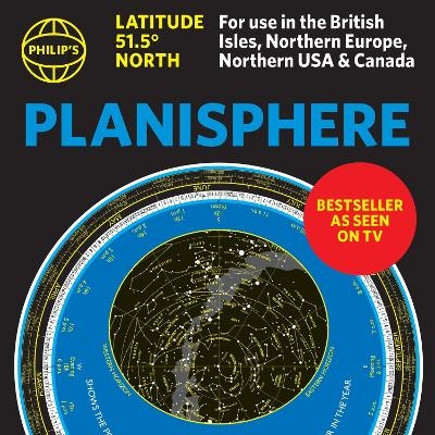
Philip's Planisphere (Latitude 51.5 North)
For use in Britain and Ireland, Northern Europe, Northern USA and Canada
Seiten
2025
Philip's
978-1-84907-710-1 (ISBN)
Philip's
978-1-84907-710-1 (ISBN)
- Noch nicht erschienen (ca. März 2025)
- Versandkostenfrei innerhalb Deutschlands
- Auch auf Rechnung
- Verfügbarkeit in der Filiale vor Ort prüfen
- Artikel merken
The first thing that every stargazer needs - an hour-by-hour and night-by-night map of the stars you can see. The bestselling specially-created moveable map of the stars dials up the constellations for really easy identification.
The first thing that every stargazer needs - an hour-by-hour and night-by-night moveable map of the stars
'A really useful bit of kit...a map of the night sky for any time of the year' Mark Thompson, TV Astronomer on BBC Stargazing Live
- Just turn the disc and 'dial up' tonight's night sky
- Bestselling and accurate sky map for every hour of every night 24/7/365
- Simple and fun to use for beginners - and an essential tool for experienced astronomers
- All the stars and constellations down to magnitude 5 (visible with the naked eye)
- Planet Tracker for the major visible planets
- Full instructions and hints on exploring the skies by season
- Suitable for UK, Ireland, Northern Europe, Canada and Northern USA (51.5N plus or minus 10 degrees)
Philip's have created a bestselling, practical, hour-by-hour tracker of the stars and constellations. Turn the oval panel to tonight's date and time - and reveal the whole sky star by star visible from where you are. The map shows stars down to magnitude 5, plus several important deep-sky objects such as the Pleiades, the Andromeda Galaxy (M31) and the Orion Nebula (M42) The Planisphere is based at 51.5 degrees North. So it's perfect for stargazers in the UK, Ireland, Northern Europe, the Northern US and Canada and comes in it's own wallet.
Philip's has been at the forefront of creating maps and atlases since 1834. Whether a local street map or a fact-packed World Atlas, we use the most up-to-date technology, expertise and our global network to ensure our customers have all the information they need.
| Erscheint lt. Verlag | 6.3.2025 |
|---|---|
| Reihe/Serie | Philip's Stargazing |
| Verlagsort | London |
| Sprache | englisch |
| Maße | 296 x 304 mm |
| Gewicht | 236 g |
| Themenwelt | Sachbuch/Ratgeber ► Natur / Technik ► Weltraum / Astronomie |
| Kinder- / Jugendbuch ► Sachbücher ► Naturwissenschaft / Technik | |
| Naturwissenschaften ► Physik / Astronomie ► Astronomie / Astrophysik | |
| ISBN-10 | 1-84907-710-X / 184907710X |
| ISBN-13 | 978-1-84907-710-1 / 9781849077101 |
| Zustand | Neuware |
| Haben Sie eine Frage zum Produkt? |
Mehr entdecken
aus dem Bereich
aus dem Bereich
Set à 10 Exemplare
Postkartenbuch/-set (2023)
Nachtschatten Verlag
16,00 €
Set à 10 Exemplare
Postkartenbuch/-set (2024)
Nachtschatten Verlag
16,00 €

