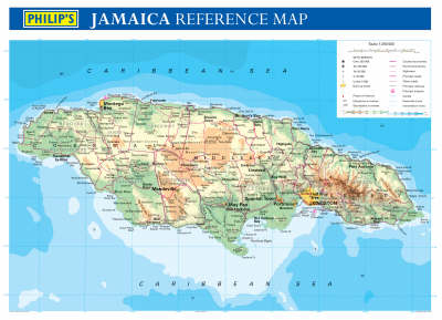
Philip's Jamaica Wall Map
2003
|
3rd Revised edition
Philip's (Verlag)
978-0-540-08315-2 (ISBN)
Philip's (Verlag)
978-0-540-08315-2 (ISBN)
- Titel ist leider vergriffen;
keine Neuauflage - Artikel merken
This large-scale topographical map of Jamaica (scale 1:250, 000) uses clear lettering and symbols to enable cities and towns, as well as rivers and other physical features, to be easily identified.The wall chart is also available rolled flat in a clear plastic tube and laminated on both sides.
This large-scale topographical map of Jamaica (scale 1:250, 000) uses clear lettering and symbols to enable cities and towns, as well as rivers and other physical features, to be easily identified. The wall chart is available either rolled flat in a clear plastic tube and laminated on both sides or unlaminated and folded into a wraparound card cover and shrinkwrapped. It is designed for mounting on a bedroom wall or in the classroom or office and the clarity of the name detail should make it accessible for both adults and children.
This large-scale topographical map of Jamaica (scale 1:250, 000) uses clear lettering and symbols to enable cities and towns, as well as rivers and other physical features, to be easily identified. The wall chart is available either rolled flat in a clear plastic tube and laminated on both sides or unlaminated and folded into a wraparound card cover and shrinkwrapped. It is designed for mounting on a bedroom wall or in the classroom or office and the clarity of the name detail should make it accessible for both adults and children.
| Erscheint lt. Verlag | 17.3.2003 |
|---|---|
| Zusatzinfo | Col.M. |
| Verlagsort | London |
| Sprache | englisch |
| Maße | 1070 x 770 mm |
| Gewicht | 112 g |
| Themenwelt | Reisen ► Karten / Stadtpläne / Atlanten ► Nord- / Mittelamerika |
| Kinder- / Jugendbuch ► Sachbücher | |
| ISBN-10 | 0-540-08315-1 / 0540083151 |
| ISBN-13 | 978-0-540-08315-2 / 9780540083152 |
| Zustand | Neuware |
| Informationen gemäß Produktsicherheitsverordnung (GPSR) | |
| Haben Sie eine Frage zum Produkt? |
Mehr entdecken
aus dem Bereich
aus dem Bereich
Karte (gefalzt) (2024)
Freytag-Berndt und ARTARIA (Verlag)
12,90 €
Karte (gefalzt) (2023)
Reise Know-How Peter Rump GmbH (Verlag)
12,00 €
Manhattan (Upper), Manhattan (Lower & Midtown), Financial
Karte (gefalzt) (2020)
Borch (Verlag)
8,90 €


