


Collins World Map with Flags
2000
|
New edition
Collins (Verlag)
978-0-00-710283-9 (ISBN)
Collins (Verlag)
978-0-00-710283-9 (ISBN)
- Titel ist leider vergriffen;
keine Neuauflage - Artikel merken
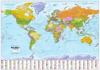
This is a poster version of Collins World Map with Flags; it includes a clear colourful world map showing countries, capital cities, other important cities, and flags and time zones.
A completely up-dated world map, showing all the countries of the world clearly and accurately, and the flags of over two hundred countries and territories. Time Zones are shown every hour.
An ideal map for any one who wants a clear, simple map, particularly suitable for children and the classroom; this poster version is ideal for wall display.
| Erscheint lt. Verlag | 3.7.2000 |
|---|---|
| Verlagsort | London |
| Sprache | englisch |
| Maße | 1016 x 840 mm |
| Gewicht | 148 g |
| Themenwelt | Reisen ► Karten / Stadtpläne / Atlanten ► Welt / Arktis / Antarktis |
| Geisteswissenschaften ► Geschichte ► Hilfswissenschaften | |
| ISBN-10 | 0-00-710283-6 / 0007102836 |
| ISBN-13 | 978-0-00-710283-9 / 9780007102839 |
| Zustand | Neuware |
| Haben Sie eine Frage zum Produkt? |
Mehr entdecken
aus dem Bereich

aus dem Bereich
1:30 Mio. mit Posterleisten, mit Oberflächenlaminat
Karte (gerollt) (2023)
INTERKART Landkarten & Globen (Verlag)
25,90 €