


Scotland of Old
Clans Map of Scotland
2012
|
New edition
Collins (Verlag)
978-0-00-748590-1 (ISBN)
Collins (Verlag)
978-0-00-748590-1 (ISBN)
- Titel erscheint in neuer Auflage
- Artikel merken
Zu diesem Artikel existiert eine Nachauflage
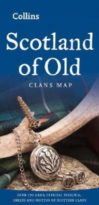
A unique pictorial map of Scotland showing the ancient territories of the principal Scottish clans in the 17th century, and features Don Pottinger’s (Islay Herald of Arms) distinctive and original artwork of Scottish arms and crest badges.
The map includes:
Over 170 arms, the official insignia of clan chiefs, and crest badges.
Territories map of principal clans at the beginning of the 17th century.
Arms of the ancient Scottish principalities.
Locations of the ancient territories held by the clans around the time of King James VI.
The map is ideal for those those with an interest in Scottish heraldry, clans and family history.
Did you know that Scotland is one of the few countries in the world where a court of heraldry and genealogy operates on a daily basis?
The map is based on the map originally conceived and illustrated by the late Sir Iain Moncreiffe of that Ilk, Bart., C.V.O., Q.C., Ph.D., Albany Herald of Arms, and the late Don Pottinger, C.V.O., M.A., D.A., Islay Herald of Arms.
Discover the other titles in the series, including Collins Tartans Map of Scotland, Castles Map of Scotland and Whisky Map of Scotland.
Explore the world through accurate and up-to-date mapping.
| Erscheint lt. Verlag | 5.7.2012 |
|---|---|
| Reihe/Serie | Collins Pictorial Maps |
| Zusatzinfo | Index |
| Verlagsort | London |
| Sprache | englisch |
| Maße | 124 x 257 mm |
| Gewicht | 70 g |
| Themenwelt | Reiseführer ► Europa ► Schottland |
| Geisteswissenschaften ► Geschichte ► Hilfswissenschaften | |
| ISBN-10 | 0-00-748590-5 / 0007485905 |
| ISBN-13 | 978-0-00-748590-1 / 9780007485901 |
| Zustand | Neuware |
| Informationen gemäß Produktsicherheitsverordnung (GPSR) | |
| Haben Sie eine Frage zum Produkt? |