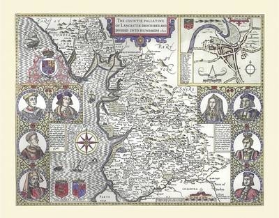
John Speed Map of Lancashire 1611
20" x 16" Photographic Print of the County of Lancashire - England
2010
Historical Images Ltd (Verlag)
978-1-84491-016-8 (ISBN)
Historical Images Ltd (Verlag)
978-1-84491-016-8 (ISBN)
Map of Lancashire originally published in 1611 by John Speed, digitally re-mastered from an antique original and printed onto photographic quality media. Supplied flat in a polypropylene sleeve and back board, the 20" x 16" (approx. 508 mm x 406 mm) print can be removed from the protective sleeve for framing or retained in the sleeve.
In the top right hand corner is a plan of Lancaster, along with a legend detailing the streets and main buildings of the town. Along the sides of the map are lovely portraits of the prominent figures of the Houses of Lancaster and York, with two short histories of them. The coat of arms of Edmund Crouchback, Earl of Lancaster, and John of Gaunt, Duke of Lancaster are also shown. Amongst others, the small towns of Liverpool and Manchester, now huge cities, are marked; along with rivers such as the Mersey, forests, hills and marshes, and even a mermaid combing her hair in the Irish Sea!
In the top right hand corner is a plan of Lancaster, along with a legend detailing the streets and main buildings of the town. Along the sides of the map are lovely portraits of the prominent figures of the Houses of Lancaster and York, with two short histories of them. The coat of arms of Edmund Crouchback, Earl of Lancaster, and John of Gaunt, Duke of Lancaster are also shown. Amongst others, the small towns of Liverpool and Manchester, now huge cities, are marked; along with rivers such as the Mersey, forests, hills and marshes, and even a mermaid combing her hair in the Irish Sea!
| Erscheint lt. Verlag | 19.2.2010 |
|---|---|
| Verlagsort | Truro |
| Sprache | englisch |
| Themenwelt | Sachbuch/Ratgeber ► Geschichte / Politik ► Regional- / Landesgeschichte |
| Geschichte ► Allgemeine Geschichte ► Neuzeit (bis 1918) | |
| Geisteswissenschaften ► Geschichte ► Hilfswissenschaften | |
| Geisteswissenschaften ► Geschichte ► Regional- / Ländergeschichte | |
| ISBN-10 | 1-84491-016-4 / 1844910164 |
| ISBN-13 | 978-1-84491-016-8 / 9781844910168 |
| Zustand | Neuware |
| Haben Sie eine Frage zum Produkt? |