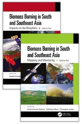
Biomass Burning in South and Southeast Asia, Two Volume Set
CRC Press
978-0-367-07516-3 (ISBN)
- Titel z.Zt. nicht lieferbar
- Versandkostenfrei innerhalb Deutschlands
- Auch auf Rechnung
- Verfügbarkeit in der Filiale vor Ort prüfen
- Artikel merken
The increasing intensity and frequency of natural disasters all around the world has caused severe socioeconomic impacts, especially in South and Southeast Asia. This region is particularly susceptible to vegetation fires, leading to biomass burning pollution with impacts on other countries through trans-boundary air pollution. Despite the growing body of information on biomass pollutants worldwide, only a modest amount of data from these regions are available. With fires and biomass burning identified as a vital issue in South/Southeast Asia, this two-volume set was created to meet community research and application needs. To better serve the atmospheric, environmental, and remote sensing communities, and to address air quality, climate, and the human health impacts of greenhouse gases and aerosols from biomass burning, this set brings together the collective achievements of experts in these regions and the state-of-the-art technologies and spatial analyses to model and monitor biomass burning events and their impacts.
This first volume covers various topics on fire, biomass burning, mapping and monitoring while the second volume highlights the impact of biomass burning on the biosphere and reflects extensive research by interdisciplinary teams of experts. This set will serve as a valuable resource for remote sensing scientist, geographers, ecologists, atmospheric scientists, environmental scientists, and all who wish to advance their knowledge on fires, biomass burning, and biomass burning pollution in South/Southeast Asia
Specific Features:
Unique in its discussion of the sources and the causes of biomass burning and atmospheric research in South and Southeast Asia.
Explains how remote sensing and geospatial technologies help the mapping and monitoring of biomass burning events and their impacts.
Focuses on large spatial scales integrating top-down and bottom-up methodologies.
Addresses the pressing issues of environmental pollution that are rampant in South and Southeast Asia.
Includes contributions from global experts currently working on biomass burning projects in the US, Japan, South/Southeast Asia, and Europe.
Krishna Prasad Vadrevu is a scientist at the NASA Marshall Space Flight Center, Huntsville, Alabama, USA. His current research is on remote sensing of land cover and land use change (LCLUC). He has 17 years of research experience and is interested in land-atmosphere interactions. He also serves as the lead scientist for NASA South/Southeast Research Initiative and coordinator for the NASA LCLUC program. Toshimasa Ohara is a scientist at National Institute of Environmental Studies, Tsukuba, Japan. He has 32 years of research experience in air quality modeling, emission inventories, and pollution research. He is a lead developer for Regional Emission Inventory in Asia (REAS) and currently interested in linking top-down and bottom- up approaches for emissions quantification. Christopher Justice is a full professor at the Department of Geographical Sciences, University of Maryland, College Park, USA. He has 38 years of research experience in remote sensing. His current research is on land cover and land use change, global fire, and global agricultural monitoring systems, all using remote sensing. He is the NASA LCLUC program scientist, member of MODIS science team, and global implementation lead for the GEO Global Agricultural Monitoring Task. He is also co-director for the center of Global Agricultural Monitoring and Research.
Volume 1: Biomass Burning in South and Southeast Asia - Needs and Priorities. Section 1 Mapping and Monitoring of Fires Including Burned Areas. Identification of Smoldering Peatland Fires in Indonesiat via Triple-phase Temperature Analysis of VIIRS Nighttime Data. Evaluation of Sentinel3 SLSTR data for Mapping Fires in Forests, Peatlands and Croplands - A Case Study Over Australia, Indonesia, and India. An Assessment of Burnt Area Signal Variations in Laos using Sentinel-1A&B Datasets. Peatland Surface Loss Due to Fires in Central Kalimantan, Indonesia - A Case Study Using Differential Interferometry SAR (DInSAR). Burnt Areas Mapping in Nainital, Uttarakhand, India using very high resolution Planetscope Imagery. Investigations on Land and Forest Fires in the North Indian Region Over a Decade. Spatial Point Patterns and Scale Analysis of Vegetation Fires in Laos and Cambodia. Section 2 Land Use, Forests, and Biomass Burning. Vegetation Fire Status and Management in Bhutan. Biomass Burning in Malaysia: Sources and Impacts. Swidden Agriculture and Biomass Burning in the Philippines. Section 3 Climate Drivers and Biomass Burning. Fire Danger Indices and Methods: An Appraisal. Air pollution conditions near peat fire prone areas during El Niño in Central Kalimantan, Indonesia. Biomass Burning and Haze in Indonesia, long term climate perspective, and impact to regional Air Quality. Meteorological Drivers of Anomalous Wildfire Activity in the Western Ghats, India. Geochemical evidence for biomass burning signals on Tibetan glaciers.
Volume 2: Section 1 Biomass Burning and Regional Air Quality. Impacts of biomass and garbage burning on air quality on South/Southeast Asia. Biomass Burning and their Impacts on Air Quality in Thailand. Impact of Biomass Burning on Local Air Quality in South China. Impact of biomass burning on surface level Carbon Monoxide over Lahore and Karachi and their comparison with South Asian megacities. Section 2 Biomass Burning Emissions. Estimating biomass burning emissions in South and Southeast Asia from 2001 to 2017 based on satellite observation. Black Carbon Emissions from Biomass Burning in Southeast Asia - A Review. Satellite-based estimation of global CO2 emissions from biomass burning. Biomass Burning Mercury Emissions over the Maritime Continent. Biomass Burning Emissions in Indonesia and Policy Measures - An Overview. PM2.5 emissions from biomass burning in South/Southeast Asia - Uncertainties and Trade-offs. Greenhouse Gas and Particulate Matter Emissions from Rice Residue Burning in Punjab and Haryana States of India. Section 3 Aerosol Pollution and Biomass Burning. Biomass Burning and Impacts on Aerosols: Optical Properties and Radiative Effects. Remotely Sensed Particulate Matter Estimation in Malaysia during the Biomass Burning Season in Southeast Asia. Impacts of Smoke Aerosols over Northern Peninsular Southeast Asia: Results from 7-SEAS Campaigns. Temporal Variation and Source Apportionment of PM2.5 Constituents, Phuket, Thailand. The impacts of biomass burning aerosols on air quality and convective systems in Southeast Asia. Biomass Burning Influence on PM2.5 Regional and Long-Range Transport in Northeast . Estimation of PM10 Concentration from Biomass Burning and Anthropogenic Emission Using WRF-HYSPLIT Modeling System
| Erscheint lt. Verlag | 24.6.2021 |
|---|---|
| Zusatzinfo | 65 Line drawings, color; 130 Halftones, color; 195 Illustrations, color |
| Verlagsort | London |
| Sprache | englisch |
| Maße | 156 x 234 mm |
| Gewicht | 1746 g |
| Themenwelt | Naturwissenschaften ► Geowissenschaften ► Geografie / Kartografie |
| Naturwissenschaften ► Physik / Astronomie ► Angewandte Physik | |
| Technik ► Umwelttechnik / Biotechnologie | |
| Weitere Fachgebiete ► Land- / Forstwirtschaft / Fischerei | |
| ISBN-10 | 0-367-07516-4 / 0367075164 |
| ISBN-13 | 978-0-367-07516-3 / 9780367075163 |
| Zustand | Neuware |
| Informationen gemäß Produktsicherheitsverordnung (GPSR) | |
| Haben Sie eine Frage zum Produkt? |
aus dem Bereich


