


Philip's World Wall Map
Junior Edition
Seiten
2007
Philip's (Verlag)
978-0-540-09176-8 (ISBN)
Philip's (Verlag)
978-0-540-09176-8 (ISBN)
- Titel erscheint in neuer Auflage
- Artikel merken
Zu diesem Artikel existiert eine Nachauflage
A brightly coloured wall map suitable for young children of primary and early secondary school age. It shows the whole of the World in political colours at a scale of 1:38 000 000 (1 cm on the map = 380 km on the ground), with lettering and symbols.
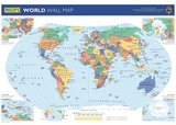
New for 2007, this brightly coloured wall map has been specially created for young children of primary and early secondary school age. It shows the whole of the World in political colours at a scale of 1:38 000 000 (1 cm on the map = 380 km on the ground), with clear large-size lettering and symbols. Individual countries are picked out in bright distinctive colours for easy identification, with major town and city names clearly shown, as well as major rivers. Larger-scale political maps are provided for the crowded regions of Europe and the Caribbean (each at a scale of 1:20 000 000), and there are additional maps of the Arctic and Antarctica (each at a scale of 1:50 000 000) and a Pacific-centred map of the continents.Philip's World Wall Map is supplied laminated on one side and rolled into a clear plastic tube. It is ideal for mounting on a classroom wall or in the bedroom. The clarity of the map detail ensures that it is highly accessible for children, teachers and parents alike. Main map projection: Hammer Equal Area.
New for 2007, this brightly coloured wall map has been specially created for young children of primary and early secondary school age. It shows the whole of the World in political colours at a scale of 1:38 000 000 (1 cm on the map = 380 km on the ground), with clear large-size lettering and symbols. Individual countries are picked out in bright distinctive colours for easy identification, with major town and city names clearly shown, as well as major rivers. Larger-scale political maps are provided for the crowded regions of Europe and the Caribbean (each at a scale of 1:20 000 000), and there are additional maps of the Arctic and Antarctica (each at a scale of 1:50 000 000) and a Pacific-centred map of the continents.Philip's World Wall Map is supplied laminated on one side and rolled into a clear plastic tube. It is ideal for mounting on a classroom wall or in the bedroom. The clarity of the map detail ensures that it is highly accessible for children, teachers and parents alike. Main map projection: Hammer Equal Area.
| Erscheint lt. Verlag | 26.10.2007 |
|---|---|
| Verlagsort | London |
| Sprache | englisch |
| Maße | 44 x 340 mm |
| Gewicht | 143 g |
| Themenwelt | Schulbuch / Wörterbuch |
| ISBN-10 | 0-540-09176-6 / 0540091766 |
| ISBN-13 | 978-0-540-09176-8 / 9780540091768 |
| Zustand | Neuware |
| Haben Sie eine Frage zum Produkt? |
Mehr entdecken
aus dem Bereich

aus dem Bereich
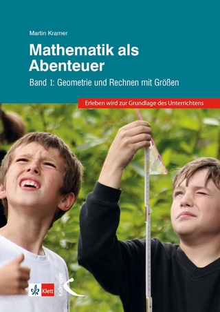
Geometrie und Rechnen mit Größen
Buch | Hardcover (2024)
Kallmeyer (Verlag)
29,95 €
Buch | Softcover (2024)
Community Editions (Verlag)
14,00 €