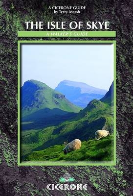
The Isle of Skye
Cicerone Press (Verlag)
978-1-85284-560-5 (ISBN)
- Titel ist leider vergriffen;
keine Neuauflage - Artikel merken
Guidebook to walks and scrambles on the Isle of Skye, in the Hebrides, just off the northwest Scottish mainland visits all corners of the island as well as the renowned Cuillin. Updated using digital mapping and GPS technology, and taking account of changes brought about by recent forestry work, it includes demanding days as tough as anything in Britain in wonderfully isolated situations over high mountains and strange pinnacles, past lonely lochans, along cliffs and through forests. Skye has some of the most awe-inspiring scenery of Scotland's many islands - a place of whose surface man has barely scratched, with almost supernatural charisma. Covered here are 87 walks and scrambles in Sleat and South-East Skye, Strath, Minginish, Duirinish, Waternish and Trotternish with a selection of routes for all abilities, from novice walker to experienced scrambler. Each route description highlights local historical and geological points of interest along the routes and is illustrated with OS mapping and colour photographs.
A writer and photographer since 1978, Terry Marsh specialises in the outdoors, the countryside, walking and travel worldwide. He is the author of over 45 books, including the award-winning Cicerone guides to the Northern Coast to Coast Walk, The Dales Way, Walking on the Isle of Man and The West Highland Way.
Acknowledgements
Preface
Introduction
History
Geology
Flora and Fauna
How to get there
Facilities and accommodation
Using this guide
Access
Safety
Maps
Paths
Language
The Walks
1SLEAT AND SOUTH-EAST SKYE
1.1Gleann Meadhonach, Loch a'Ghlinne and Dalavil
1.2Acairseid an Rubha and Point of Sleat
1.3Armadale
1.4Sgurr na Coinnich
1.5Beinn na Caillich
1.6Ben Aslak
1.7Kylerhea Glen Circuit
1.8Coastal Path from Loch na Dal to Kylerhea
1.9Kylerhea Trail
2STRATH
Broadford
2.1Broadford Coast Path (Irishman's Point)
North of Strath Suardal
2.2Coire Gorm Horseshoe
2.3Beinn na Cro
2.4Srath Mór and Srath Beag
South of Strath Suardal
2.5Suisnish and Boreraig
Cuillin Outliers
2.6Bla Bheinn
2.7Sgurr nan Each
2.8Garbh-bheinn
2.9Belig
2.10Glas Bheinn Mhór
2.11South Ainort Circular
The Red Hills
2.12Marsco
2.13The Beinn Deargs
2.14Glamaig
2.15Glen Sligachan
Strathaird Peninsula
2.16Kilmarie to Camasunary
2.17Camasunary to Elgol
2.18Suidhe Biorach (Prince Charles' Cave)
2.19Rubha na h-Easgainne
2.20Spar Cave
3MINGINISH
indicates that the walk cannot be completed at all or in part without scrambling ability, as a minimum.
The Cuillin
3.1Sgurr nan Gillean
3.2Sgurr Beag and Sgurr na h-Uamha
3.3Coire a'Bhasteir Am Basteir
3.4Sgurr a'Bhasteir
3.5Fionn Choire, Bealach nan Lice and Sgurr a'Fionn Choire
3.6Bruach na Frithe
3.7Coire na Creiche
3.8Coire a'Ghreadaidh
3.9Sgurr Thuilm, Sgurr a'Mhadaidh and Sgurr a'Ghreadaidh
3.10Sgurr na Banachdich and Sgurr nan Gobhar
3.11Eas Mor and Coire na Banachdich
3.12Sgurr Dearg and Inaccessible Pinnacle
3.13Coire Lagan
3.14Sgurr Alasdair
3.15Coir' a'Ghrunnda and Loch Coir' a'Ghrunnda
3.16The South Cuillin ridge
3.17Loch an Fhir-bhallaich
3.18Rubh' an Dùnain
Glen Sligachan
3.19Harta and Lota Corries
3.20Druim Hain and Sgurr na Stri
3.21Loch Coruisk
Loch Brittle to Loch Bracadale
3.22Glen Brittle Forest Walk
3.23Talisker Bay
3.24Oronsay
4DUIRINISH
4.1Loch Bharcasaig, Idrigill Point and MacLeod's Maidens
4.2Glen Ollisdal and MacLeod's Maidens
4.3Duirinish Coastal Path
4.4Healabhal Bheag (MacLeod's Table South)
4.5Healabhal Mhor (MacLeod's Table North)
4.6Lorgill Bay
4.7Lorgill, The Hoe and Ramasaig Bay
4.8Waterstein Head
4.9Neist Point
4.10Uiginish Point
4.11The Coral Beaches
4.12Lovaig Bay
5WATERNISH
5.1Ardmore Point
5.2Unish and Waternish Point
5.3Beinn an Sguirr
5.4Loch Diubaig and Greshornish Point
6TROTTERNISH AND PORTREE
Trotternish
6.1Meall Tuath and Rubha Hunish
6.2Loch Sneosdal and Creag Sneosdal
6.3Loch Hasco
6.4The Quiraing and Meall na Suiramach
6.5Meall na Suiramach
6.6The Old Man of Storr
6.7The Storr
6.8The Trotternish Ridge
6.9Biode Buidhe
6.10Beinn Edra
6.11Ruadh nam Brathairean (Brothers' Point)
6.12Loch Cuithir, Sgurr a'Mhadaidh Ruaidh and Baca Ruadh
6.13Inver Tote and the Lealt waterfall
6.14Bearreraig Bay
6.15Sithean Bhealaich Chumhaing
Portree
6.16Glen Varrigill Forest Walk
6.17Ben Tianavaig
6.18The Braes
APPENDIX 1Essential and supplementary reading
APPENDIX 2Glossary of Gaelic words
APPENDIX 3Useful information and contact details
INDEX
| Erscheint lt. Verlag | 9.11.2012 |
|---|---|
| Zusatzinfo | 87 colour OS map extracts |
| Verlagsort | Kendal |
| Sprache | englisch |
| Maße | 116 x 172 mm |
| Gewicht | 360 g |
| Themenwelt | Sachbuch/Ratgeber ► Sport |
| Reiseführer ► Europa ► Großbritannien | |
| Reiseführer ► Europa ► Schottland | |
| ISBN-10 | 1-85284-560-0 / 1852845600 |
| ISBN-13 | 978-1-85284-560-5 / 9781852845605 |
| Zustand | Neuware |
| Haben Sie eine Frage zum Produkt? |
aus dem Bereich


