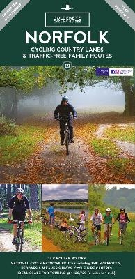
Norfolk Cycling Country Lanes Map
Goldeneye (Verlag)
978-1-85965-292-3 (ISBN)
Explore Norfolk by bike with this laminated, waterproof Norfolk map. With 24 circular, clearly-marked routes this easy-to-use map will help you discover the best of the Norfolk along the quietest country lanes.
Norfolk provides some of the greatest scenic interest in Britain with its dark forests of Breckland, rolling chalklands of the north west, the unique watery patch of the Norfolk Broads and a stunning coastline. It is also one of the flattest counties and our circular routes have been chosen to explore the quiet lanes linking the isolated and picturesque villages and places of interest. This is ideal cycling territory for families wanting a day out as well as the committed touring cyclists.
Our Norfolk Cycling Country Lanes map includes:
* Traffic-free family routes - starting at just 1 mile, this selection of traffic-free family routes includes Bacton Wood, Thetford Forest and Bure Valley Railway and Path
* National Cycle Network routes - the linked series of traffic-free paths and traffic-calmed roads being developed across the UK
* Our personal favourites - we've explored every corner of this beautiful county to bring you the best circular routes to make the most of your weekend whether you fancy a lazy meander or a full-on tour
These circular routes are all clearly marked on the map and designed to follow the quietest country lanes and to introduce you to the best of Norfolk.
Al is an Olympic Triathlete with over 43 years world-wide experience in a wide range of adventurous outdoor activities; from climbing, road cycling and mountain biking, hiking, fell running, swimming, downhill skiing and ski mountaineering. He is the author of Classic Climbs in the Dolomites (Cicerone Press 1987), Italian Rock - Selected Climbs in Northern Italy (Cicerone Press 1988), Great Routes in the Cotswolds - Mountain Bike Maps (Goldeneye 1998), Great Routes in the Peak District - Mountain Bike Maps (Goldeneye 1998), Dartmoor Mountain Bike Routes (Goldeneye 2005), and, Exmoor North Devon The Quantocks Mountain Bike Routes (Goldeneye 2004). Al has devised cycle routes for the Goldeneye range of Cycling Country Lanes & Byways to:- Dorset, Dartmoor & South Devon, Exmoor & North Devon, Lake District, North York Moors, Peak District, Pembrokeshire, Snowdonia, Suffolk and the Yorkshire Dales. He regularly contributes articles and photographs to a wide range of outdoor magazines.
| Erscheinungsdatum | 09.05.2022 |
|---|---|
| Verlagsort | Cheltenham |
| Sprache | englisch |
| Maße | 125 x 245 mm |
| Themenwelt | Sachbuch/Ratgeber ► Sport ► Motor- / Rad- / Flugsport |
| Reisen ► Karten / Stadtpläne / Atlanten ► Europa | |
| Reisen ► Reiseführer | |
| ISBN-10 | 1-85965-292-1 / 1859652921 |
| ISBN-13 | 978-1-85965-292-3 / 9781859652923 |
| Zustand | Neuware |
| Haben Sie eine Frage zum Produkt? |
aus dem Bereich


