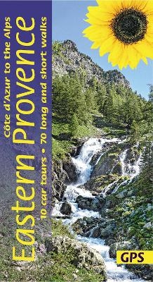
Eastern Provence Sunflower Walking Guide
Sunflower Books (Verlag)
978-1-85691-538-0 (ISBN)
The go-to Eastern Provence travel guide for over 30 years.
Strap on your boots and discover Eastern Provence on foot with the Sunflower Eastern Provence travel guide. And on the days when your feet may have had enough, enjoy some spectacular scenery on one of our legendary car tours.
The Sunflower Eastern Provence guide is indispensable for hiking in Eastern Provence or seeing Eastern Provence by car. This guide, half of a two-volume set, is intended for first-time visitors who want to tour eastern Provence and the Côte d’Azur by car and enjoy some superb walks en route. The drives have been described in such detail that there is no need to make constant reference to a map. The walks selected — all set in areas of great natural beauty and historical interest — are those the authors believe offer the greatest sense of satisfaction for the effort involved. These are not tough GR routes, but mostly circular walks suitable for moderately fit people.
Inside the Sunflower Eastern Provence guide book you’ll find:
70 long and short walks for all ages and abilities - each walk is graded so you can easily match your ability to the level of walk
Topographical walking maps - give you a clear sense of the surrounding terrain
Free downloadable gps tracks - for the techies
Satnav guidance to walk starts for motorists
10 car tours and fold-out touring map - for easy reference on your tour
Strolls to idyllic picnic spots - enjoy our recommendations for where to picnic along the way
Timetables for public transport - ideal if you want to link two walks or avoid hiring a car on your holiday
Online update service for the latest information
Whether you decide to tour Eastern Provence by car or explore on foot we look forward to showing you around.
Since 1983 people out walking in sunny climes have been relying on our ‘little blue books’ to follow the trails – and to make friends with other walkers. Sunflower started by exploring the Atlantic Islands, but has branched out: we still love islands – from the Azores to Zakynthos – but we cover many mainland destinations too, like land-locked Switzerland and the coastal Basque Country. All our guides have the familiar mix of car tours, walks and picnics. More recently, we introduced restaurants and recipes in our ‘Walk & Eat’ series, which explores around cities from Stockholm to Avignon.
Table of contents:
Preface 5
Bibliography 6
Picnicking 8
A country code for walkers and motorists 8
Touring 9
Car tour 1: THE CORNICHE D'OR AND THE ESTEREL 11
A circular tour of 174km beginning and ending at Nice
Car tour 2: THE RIVIERA AND THE MERCANTOUR 15
A tour of 216km beginning at Nice and ending
at St-Martin-Vesubie
Car tour 3: UTELLE AND THE GORGES DU LOUP 22
A tour of 200km beginning at St-Martin-Vesubie and ending at Thorenc
Car tour 4: IN NAPOLEON'S FOOTSTEPS 26
A circular tour of 203km beginning and ending at Thorenc
Car tour 5: LAC D'ALLOS 30
A tour of 123km beginning at Thorenc and ending at Colmars
Car tour 6: GORGES DU CIANS 33
A tour of 181km beginning at Colmars and ending at Thorenc
Car tour 7: RIFTS AND RIVER VALLEYS 37
A tour of 176km beginning at Thorenc and ending at Aups
Car tour 8: GRAND CANYON DU VERDON 43
A circular tour of 162km beginning and ending at Aups
Car tour 9: THE MAURES 50
A circular tour of 243km beginning and ending at Aups
Car tour 10: LA MONTAGNE STE-VICTOIRE 56
A tour of 164km beginning at Aups and ending at Aix-en-Provence
Walking 61
Weather; What to take; Nuisances; Waymarking,
grading, safety; Maps
WALKS
1 On the rooftops of Nice 64
2 Mont Chauve d'Aspremont 66
3 Peille and Peillon 68
4 Around Cap Ferrat 70
5 Ravin du Mal Infernet 72
6 Circuit above Theoule-sur-Mer 74
7 Cap du Dramont 76
8 From La Turbie to Eze-Bord-de-Mer 77
9 From Ste-Agnes to Castellar 79
10 Cap Martin 81
11 Above Sospel 82
12 Cime de l'Arpiha 84
13 Lac de Trecolpas and Refuge de la Cougourde 85
14 Col de Fenestre and Pas des Ladres 88
15 Cime du Pisset 90
16 Cascade de l'Estrech 91
17 Circuit from Gourdon 93
18 Castellaras 95
19 Source de la Siagnole 96
20 Gorges du Blavet 98
21 Gorges de la Siagne 99
22 Seranon and the Bauroux ridge 101
23 Lac d'Allos 103
24 Above Beuil 105
25 Above Puget-Theniers 107
26 Gres d'Annot 109
27 Aiglun and the Esteron River 111
28 Ville 113
29 Circuit around Comps-sur-Artuby 114
30 Above Tourtour 115
31 Sentier Martel 117
32 Belvedere de Rancoumas 120
33 Chartreuse de la Verne 122
34 Cap Lardier 123
35 La Montagne Ste-Victoire 125
36 Lac Zola 128
Train des Pignes 130
Glossary 132
Index 134
Touring map/transport information inside back cover
| Erscheinungsdatum | 15.01.2021 |
|---|---|
| Verlagsort | London |
| Sprache | englisch |
| Maße | 115 x 210 mm |
| Gewicht | 275 g |
| Themenwelt | Sachbuch/Ratgeber ► Sport |
| Reiseführer ► Europa ► Frankreich | |
| ISBN-10 | 1-85691-538-7 / 1856915387 |
| ISBN-13 | 978-1-85691-538-0 / 9781856915380 |
| Zustand | Neuware |
| Haben Sie eine Frage zum Produkt? |
aus dem Bereich


