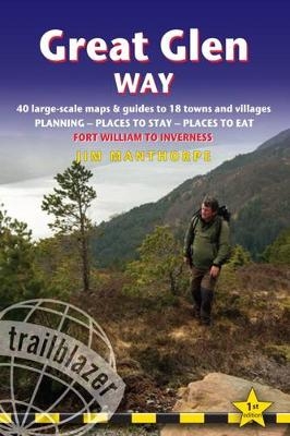
Great Glen Way
Trailblazer Publications (Verlag)
978-1-905864-80-5 (ISBN)
- Titel ist leider vergriffen;
keine Neuauflage - Artikel merken
The Great Glen Way long-distance footpath begins where the West Highland Way ends - at Fort William - and follows the Great Glen faultline to finish at Inverness after 79 miles (127km). The trail passes Loch Lochy, Loch Oich and Loch Ness and also follows the towpath of the Caledonian Canal. It's a relatively easy week-long walk amongst beautiful Highland scenery but there's a high level option between Fort Augustus and Drumnadrochit that gives even better mountain views. * Includes 38 detailed walking maps: the largest-scale maps available - at just under 1:20,000 (8cm or 31/8 inches to 1 mile) these are bigger than even the most detailed walking maps currently available in the shops * Unique mapping features - walking times, directions, tricky junctions, places to stay, places to eat, points of interest.
These are not general-purpose maps but fully edited maps drawn by walkers for walkers**With accommodation, pubs and restaurants in detailed guides to 15 towns and villages includingFort William and Inverness * Itineraries for all walkers - whether hiking the entire route or sampling highlights on day walks or short breaks *Detailed public transport information Buses and trains for all access points* Practical information for all budgets *What to see; where to eat (cafes, pubs and restaurants); where to stay (B&Bs, hotels, bunkhouses, hostels and campsites) Written by Scottish hillwalker Jim Manthorpe, this new Trailblazer guide is the 16th in our popular British Walking Guide series.
Jim Manthorpe has trekked in many of the world's mountainous regions from Patagonia to the Himalaya and Scandinavia to the Canadian Rockies. He is the author of four other Trailblazer guidebooks: Scottish Highlands, South Downs Way, Pembrokeshire Coast Path and Tour du Mont Blanc. He has also researched and updated numerous other Trailblazer titles. Jim lives on the west coast of the Scottish Highlands and now works as a wildlife cameraman and film-maker.
INTRODUCTION The Great Glen Way About the Great Glen Way 7 - History of the Great Glen Way 8 How difficult is it? 10 - How long do you need? 12 - When to go 13 PART 1: PLANNING YOUR WALK Practical information for the walker Route finding 17 - Accommodation 18 - Food and drink 21 Money 23 - Other services 24 - Information for foreign visitors 24 Walking companies 26 - Walking with a dog 28 Other options for the Great Glen Way 28 Budgeting 29 Itineraries Village and town facilities 30 - Which direction? 31 Suggested itineraries 32 - Day and weekend walks 33 Hillwalking side trips 34 What to take Keep your luggage light 34 - How to carry it 34 - Footwear 35 Clothes 36 - Toiletries 37 - First-aid kit 37 - General items 37 Camping gear 38 - Sources of further information 38 - Money 39 Maps 39 - Recommended reading 40 Getting to and from the Great Glen Way National transport 41 - Getting to Britain 42 Local transport 43 - Public transport map 45 PART 2: MINIMUM IMPACT WALKING & OUTDOOR SAFETY Minimum impact walking Economic impact 47 - Environmental impact 48 - Scottish outdoor Access code 50 - Access 51 Outdoor safety Avoidance of hazards 53 - Weather forecasts 54 - Water 54 Blisters 54 - Bites 55 - Hypothermia 56 - Hyperthermia 57 Dealing with an accident 57 PART 3: THE ENVIRONMENT & NATURE Conserving Scotland's nature Scottish Natural Heritage (SNH) 59 - The Great Glen Fault 59 Campaigning & conservation organisations 59 PART 3: THE ENVIRONMENT & NATURE (continued) Flora and fauna Trees 61 - Flowers 65 - Mammals 67 - Reptiles 70 Butterflies 70 - Birds 70 PART 4: ROUTE GUIDE AND MAPS Using this guide 74 Fort William 76 Fort William to Gairlochy 81 (Lochyside 82 - Caol 82 Corpach 86 - Banavie 87 - Gairlochy 87 - Spean Bridge 90) Gairlochy to junction by Laggan Locks 94 Side trip to the Loch Lochy munros 98 Junction by Laggan Locks to Fort Augustus 101 (Junction by Laggan Locks to Aberchalder via Laggan and Loch Oich 101 Laggan 101 - Junction by Laggan Locks to Aberchalder via Invergarry, Invergarry link route 105 - Invergarry 106 - Aberchalder to Fort Augustus 110 - Fort Augustus 111) Fort Augustus to Invermoriston 116 (High route from Fort Augustus to junction of routes 118 - Low route from Fort Augustus to junction of routes 120 - Junction of routes to Invermoriston 120 Invermoriston 120) Invermoriston to Drumnadrochit 123 Drumnadrochit 131 Drumnadrochit to Inverness 136 Inverness 144 APPENDICES A: Gaelic 151 B: GPS Waypoints 153 C: Taking a dog along the Way 155 D: Glen Nevis and Ben Nevis 157 E: Map key 165 F: Distance charts 166 INDEX 170 OVERVIEW MAPS & PROFILES 177
| Erscheinungsdatum | 19.01.2017 |
|---|---|
| Reihe/Serie | British Walking Guides |
| Zusatzinfo | 10 black & white illustrations, 10 black & white halftones, 40 colour illustrations, 38 maps, 5 charts |
| Verlagsort | Hindhead, Surrey |
| Sprache | englisch |
| Maße | 122 x 180 mm |
| Gewicht | 265 g |
| Themenwelt | Sachbuch/Ratgeber ► Sport |
| Reiseführer ► Europa ► Großbritannien | |
| Reiseführer ► Europa ► Schottland | |
| ISBN-10 | 1-905864-80-9 / 1905864809 |
| ISBN-13 | 978-1-905864-80-5 / 9781905864805 |
| Zustand | Neuware |
| Haben Sie eine Frage zum Produkt? |
aus dem Bereich


