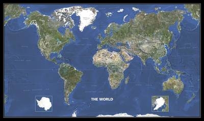
World Photo Satellite Map
Seiten
2006
Michelin Maps (Verlag)
978-2-06-712757-9 (ISBN)
Michelin Maps (Verlag)
978-2-06-712757-9 (ISBN)
- Titel ist leider vergriffen;
keine Neuauflage - Artikel merken
The satellite photo map of the world, displaying the globe's bright colorsa unique view of the earth which evokes a desire to explore the world. Laminated for durable use.
| Reihe/Serie | Michelin Karten, Plano ; Bl.13801 |
|---|---|
| Zusatzinfo | Colour Mapping |
| Verlagsort | Watford |
| Sprache | englisch |
| Maße | 73 x 1037 mm |
| Gewicht | 544 g |
| Themenwelt | Reisen ► Karten / Stadtpläne / Atlanten ► Welt / Arktis / Antarktis |
| ISBN-10 | 2-06-712757-8 / 2067127578 |
| ISBN-13 | 978-2-06-712757-9 / 9782067127579 |
| Zustand | Neuware |
| Haben Sie eine Frage zum Produkt? |
Mehr entdecken
aus dem Bereich
aus dem Bereich
Karte (gerollt) (2024)
Kümmerly+Frey (Verlag)
14,90 €


