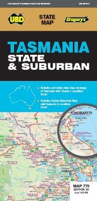
Tasmania State & Suburban Map 770 28th ed
Seiten
2021
|
Twenty-eighth Edition
UBD Gregory's (Verlag)
978-0-7319-3267-2 (ISBN)
UBD Gregory's (Verlag)
978-0-7319-3267-2 (ISBN)
- Titel ist leider vergriffen;
keine Neuauflage - Artikel merken
The latest edition of the Tasmania state and suburban map has been fully revised and updated and includes:
State map & index to towns and localities
Suburban map coverage of Hobart north to Mangalore and Runnymede south to Oyster Cove and South Arm, east to Sorell and west to Molesworth and an index to the Suburbs & Localities included in the coverage.
State map & index to towns and localities
Suburban map coverage of Hobart north to Mangalore and Runnymede south to Oyster Cove and South Arm, east to Sorell and west to Molesworth and an index to the Suburbs & Localities included in the coverage.
| Erscheint lt. Verlag | 30.12.2021 |
|---|---|
| Reihe/Serie | State Map |
| Zusatzinfo | Full colour |
| Sprache | englisch |
| Maße | 690 x 1000 mm |
| Themenwelt | Reisen ► Karten / Stadtpläne / Atlanten |
| ISBN-10 | 0-7319-3267-6 / 0731932676 |
| ISBN-13 | 978-0-7319-3267-2 / 9780731932672 |
| Zustand | Neuware |
| Informationen gemäß Produktsicherheitsverordnung (GPSR) | |
| Haben Sie eine Frage zum Produkt? |
Mehr entdecken
aus dem Bereich
aus dem Bereich
Karte (gerollt) (2023)
Freytag-Berndt und ARTARIA (Verlag)
19,90 €
Karte (gefalzt) (2023)
Freytag-Berndt und ARTARIA (Verlag)
12,90 €
Wander-, Rad- und Freizeitkarte, 7. Auflage
Karte (gefalzt) (2023)
Pietruska (Verlag)
9,90 €


