Walking on Arran
Cicerone Press (Verlag)
978-1-85284-825-5 (ISBN)
- Titel ist leider vergriffen;
keine Neuauflage - Artikel merken
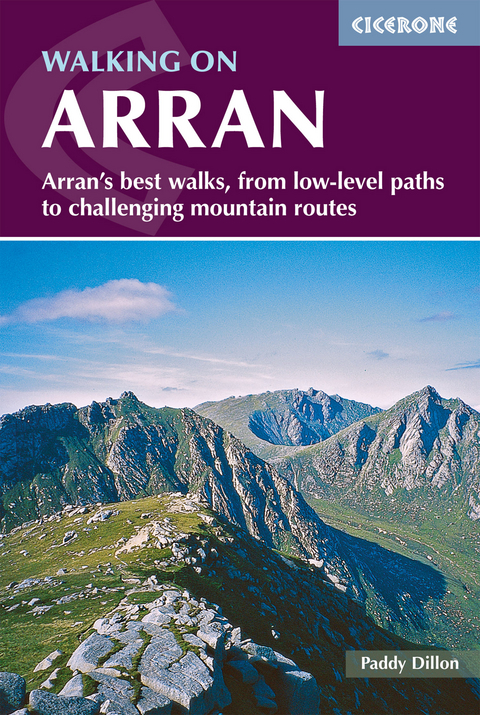
This guidebook describes 44 walks on the popular and accessible Isle of Arran. The routes are between 2 and 20 miles (3 - 32km) in length, ranging in difficulty from easy waymarked forest trails to more arduous mountain walks, exposed ridge routes and scrambles. The book includes both linear and circular walks, and there are opportunities to link routes together and create longer walks across the length and breadth of the island.
Highlights include Goatfell, the nearby Holy Isle, Beinn Nuis, Beinn Tarsuinn, the Sannox Horseshoe, Glen Rosa and the Cock of Arran. All the routes are clearly described with OS 1:50,000 mapping, with extra notes revealing the archaeology, history and natural wonders of the island. The book includes background information on travel to Arran, public transport, and a Gaelic/English glossary.
There's something here to suit walkers of all fitness levels and abilities. Often described as 'Scotland in miniature', Arran boasts a rich variety of landscapes, and walks have been chosen to showcase this variety. For an island, travel to Arran is remarkably easy: it is not far to Glasgow, from where onward connections to the Isle of Arran are swift and frequent.
Paddy Dillon is a prolific outdoor writer with over 70 guidebooks to his name, and contributions to 30 other publications. Paddy lives near the Lake District and has walked in every county in England, Scotland, Ireland and Wales. He enjoys simple day walks, challenging long-distance walks, and is a dedicated island-hopper. He has led guided walks and walked extensively in Europe, as well as in Nepal, Tibet, Korea, Africa and the Rocky Mountains of Canada and the United States.
Contents
Overview map
Map key
Introduction
Getting to the Isle of Arran
Getting around the Isle of Arran
Familiarisation with the Isle of Arran
A geology classroom
A turbulent history
Land ownership and access
Island animals
Island plants
Accommodation on the Isle of Arran
Food and drink on the Isle of Arran
The maps
The walks
Tourist information
Emergency services on the Isle of Arran
The walks
Walk 1 Goatfell and Brodick
Walk 2 Brodick Castle and Country Park
Walk 3 Brodick and the Clauchland Hills
Walk 4 Sithein and Glen Cloy
Walk 5 Lamlash and the Clauchland Hills
Walk 6 Sithein and The Ross
Walk 7 Lamlash to Brodick
Walk 8 Holy Isle from Lamlash
Walk 9 Tighvein and Monamore Glen
Walk 10 Glenashdale and Urie Loch
Walk 11 Glenashdale Falls and Giants' Graves
Walk 12 Lamlash and Kingscross
Walk 13 Eas Mòr and Loch Garbad
Walk 14 Lagg to Kildonan coastal walk
Walk 15 Kilmory forest circuit
Walk 16 Sliddery and Cnocan Donn
Walk 17 Tighvein and Glenscorrodale
Walk 18 The Ross and Cnoc a' Chapuill
Walk 19 Shiskine and Clauchan Glen
Walk 20 Balmichael and Ard Bheinn
Walk 21 The String and Beinn Bhreac
Walk 22 Blackwaterfoot and King's Cave
Walk 23 Machrie Moor Stone Circles
Walk 24 Dougarie and Beinn Nuis
Walk 25 Dougarie and Sail Chalmadale
Walk 26 Circuit of Glen Iorsa
Walk 27 Imachar and Mullach Buidhe
Walk 28 Pirnmill and Mullach Buidhe
Walk 29 Coire-Fhionn Lochan
Walk 30 Catacol and Meall nan Damh
Walk 31 Catacol and Beinn Bhreac
Walk 32 Catacol and Beinn Tarsuinn
Walk 33 Lochranza and Meall Mòr
Walk 34 Gleann Easan Biorach
Walk 35 Lochranza and the Cock of Arran
Walk 36 Lochranza and Sail an Im
Walk 37 Sannox and Fionn Bhealach
Walk 38 North Glen Sannox Horseshoe
Walk 39 Glen Sannox Horseshoe
Walk 40 Glen Sannox to Glen Rosa
Walk 41 Corrie and Goatfell
Walk 42 Glen Rosa and Beinn Tarsuinn
Walk 43 Western Glen Rosa
Walk 44 Eastern Glen Rosa
Appendix A Arran Coastal Way
Appendix B Useful contacts
Appendix C Gaelic/English glossary
| Erscheint lt. Verlag | 6.8.2019 |
|---|---|
| Reihe/Serie | Cicerone guidebooks |
| Zusatzinfo | 46 OS maps 107 colour photos |
| Verlagsort | Kendal |
| Sprache | englisch |
| Maße | 116 x 172 mm |
| Gewicht | 300 g |
| Themenwelt | Sachbuch/Ratgeber ► Sport |
| Reiseführer ► Europa ► Schottland | |
| Reisen ► Sport- / Aktivreisen ► Europa | |
| ISBN-10 | 1-85284-825-1 / 1852848251 |
| ISBN-13 | 978-1-85284-825-5 / 9781852848255 |
| Zustand | Neuware |
| Haben Sie eine Frage zum Produkt? |


