


World Political Marco Polo Wall Map
2012
Marco Polo Travel Publishing (Verlag)
978-3-8297-6777-4 (ISBN)
Marco Polo Travel Publishing (Verlag)
978-3-8297-6777-4 (ISBN)
- Titel ist leider vergriffen;
keine Neuauflage - Artikel merken
Marco Polo maps feature completely up-to-date, digitally generated mapping. A fold-out overview map is ideal for route planning and 7 self-adhesive Marco Polo mark-it stickers can be used to pin-point a destination or route for future reference.
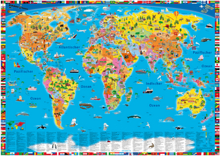
High quality, large laminated rolled map of the World (120 x 80cm) supplied in durable plastic tube. Perfect reference map covering the whole world and showing the political units on each continent, mountain relief and sea depth. Includes national flags of each country as well as country names, capital cities and country codes. Also includes inset map featuring World Time Zones. Ideal for any classroom, bedroom or office wall. Scale 1: 35 000 000.
High quality, large laminated rolled map of the World (120 x 80cm) supplied in durable plastic tube. Perfect reference map covering the whole world and showing the political units on each continent, mountain relief and sea depth. Includes national flags of each country as well as country names, capital cities and country codes. Also includes inset map featuring World Time Zones. Ideal for any classroom, bedroom or office wall. Scale 1: 35 000 000.
Marco Polo Travel Publishing offers a wide range of high quality cartographic products and travel guides. Marco Polo Pocket Guides are known for their handy, compact format and Insider Tips. Our Travel Handbooks are the first to include infographics and our Spiral Guides feature unique lay-flat spiral binding. Marco Polo Maps are famous for the high quality of cartography in their Country, City and Holiday Maps.
| Reihe/Serie | Marco Polo Maps |
|---|---|
| Zusatzinfo | Farb. Abb., Fotos, Kartenausschnitte |
| Verlagsort | Ostfildern |
| Sprache | englisch |
| Maße | 60 x 870 mm |
| Themenwelt | Reisen ► Karten / Stadtpläne / Atlanten ► Welt / Arktis / Antarktis |
| Reisen ► Reiseführer | |
| ISBN-10 | 3-8297-6777-3 / 3829767773 |
| ISBN-13 | 978-3-8297-6777-4 / 9783829767774 |
| Zustand | Neuware |
| Haben Sie eine Frage zum Produkt? |
Mehr entdecken
aus dem Bereich


aus dem Bereich
Karte (gerollt) (2024)
Kümmerly+Frey (Verlag)
14,90 €