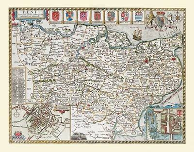
John Speed's Map of Kent 1611
30" x 25" Large Photographic Poster Print Kent - England
2010
Historical Images Ltd (Verlag)
978-1-84491-457-9 (ISBN)
Historical Images Ltd (Verlag)
978-1-84491-457-9 (ISBN)
Map of Kent originally published in 1611 by John Speed, digitally re-mastered from an antique original and printed onto photographic quality media. This larger sized format 30" x 25" (approx. 762 mm x 635 mm) is supplied rolled in a heavy duty protective cardboard tube.
Plans of Canterbury, with its cathedral, and Rochester are shown in the bottom corners. The armorial devices of the Earls of Kent are depicted along the top, with the Royal coat of arms on their right. The towns of Greenwich before becoming famous for its meridian and Sandwich are also shown on this wonderful example of John Speed's work.
Plans of Canterbury, with its cathedral, and Rochester are shown in the bottom corners. The armorial devices of the Earls of Kent are depicted along the top, with the Royal coat of arms on their right. The towns of Greenwich before becoming famous for its meridian and Sandwich are also shown on this wonderful example of John Speed's work.
| Erscheint lt. Verlag | 1.1.2010 |
|---|---|
| Verlagsort | Truro |
| Sprache | englisch |
| Themenwelt | Geisteswissenschaften ► Geschichte ► Hilfswissenschaften |
| ISBN-10 | 1-84491-457-7 / 1844914577 |
| ISBN-13 | 978-1-84491-457-9 / 9781844914579 |
| Zustand | Neuware |
| Haben Sie eine Frage zum Produkt? |