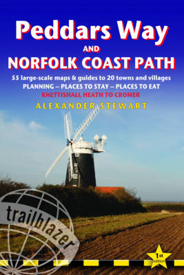
Peddars Way and Norfolk Coast Path: Trailblazer British Walking Guide
Trailblazer Publications (Verlag)
978-1-905864-28-7 (ISBN)
- Titel ist leider vergriffen;
keine Neuauflage - Artikel merken
Practical guide to walking the whole Peddars Way and Norfolk Coast Path. The Peddars Way & Norfolk Coast Path is a 93-mile (150km) National Trail that runs from Knettishall Heath Country Park on the Norfolk/Suffolk border in East Anglia, and follows a Roman road to Holme-next-the-Sea and along the beautiful Norfolk coastline through Holkham, Blakeney and Cley to end at Cromer. The guide includes: Peddars Way and Norfolk Coast map, 54 large-scale detailed walking maps (1:20,000), guides to 28 towns and villages. Detailed accommodation guide: campsites, B&Bs, hostels, hotels, bunkhouses. Where to eat: cafes, teashops, pubs and restaurants. Detailed public transport information. Itineraries for all walkers including one day Peddars Way and Norfolk Coast Path walks. Downloadable GPS waypoints. Colour pictures including a 6 page colour bird and flower guide.
Alex Stewart is also the author of Trailblazer guides: New Zealand - the Great Walks, The Walker's Haute Route, and The Inca Trail, Cusco & Machu Picchu 5th edition.
INTRODUCTION (1) PART 1: PLANNING YOUR WALK - About the Peddars Way and Norfolk Coast Path (History, How difficult is the path, How long do you need?), Practical information for the visitor (Accommodation, Food and drink, Money, Other services, Information for foreign visitors, Walking companies), Budgeting (Accommodation, Extras), When to go (Seasons, Temperature and rainfall, Daylight hours, Annual events), Itineraries (Which direction? Highlights, Village and town facilities, Suggested itineraries, Mountain biking, Walking with dogs), What to take (Keep it light, How to carry it, Footwear, Clothes, Toiletries, First-aid kit, General items, Sleeping bag, Camping gear, Money, Maps, Recommended reading), Getting to and from the region (National transport, Getting to Britain, Local transport, Local transport map and details) Sources of further information (2) PART 2: MINIMUM IMPACT TREKKING Economic impact, Environmental impact, Access, Outdoor safety (Avoidance of hazards, Weather forecasts, Blisters, Hypothermia, Heat exhaustion and heatstroke, Sunburn) (3) PART 3: THE ENVIRONMENT AND NATURE Conserving the Peddars Way and Norfolk Coast Path (Natural Heritage, Campaigning & conservation organizations), Fauna and flora (Mammals, Reptiles, Birds, Trees, Flowers (4) PART 4: ROUTE GUIDE & MAPS Using this guide - Stage 1 - Stage 2 - Stage 3 - Stage 4 - Stage 5 - Stage 6 - Stage 7 (5) APPENDICES (6) MAP KEYS (7) INDEX
| Erscheint lt. Verlag | 18.2.2011 |
|---|---|
| Reihe/Serie | British Walking Guides |
| Zusatzinfo | colour photos, 50 large-scale BW walking maps, 10 town plans |
| Verlagsort | Hindhead, Surrey |
| Sprache | englisch |
| Maße | 120 x 180 mm |
| Gewicht | 16 g |
| Themenwelt | Sachbuch/Ratgeber ► Sport |
| Reiseführer ► Europa ► Großbritannien | |
| ISBN-10 | 1-905864-28-0 / 1905864280 |
| ISBN-13 | 978-1-905864-28-7 / 9781905864287 |
| Zustand | Neuware |
| Haben Sie eine Frage zum Produkt? |
aus dem Bereich


