Philip's Map of the World
2006
|
Revised edition
Philip's (Verlag)
978-0-540-08971-0 (ISBN)
Philip's (Verlag)
978-0-540-08971-0 (ISBN)
- Titel ist leider vergriffen;
keine Neuauflage - Artikel merken
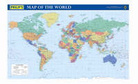
Presents a compact wall chart, featuring a coloured map of the world, in political coloration and with lettering and symbols for easy reference. Countries are picked out in distinctive colours to aid identification, with town and city names clearly shown.
Created from the latest digital cartography, this new edition compact wall chart features a brightly coloured map of the world, in political coloration and with clear lettering and symbols for easy reference. Countries are picked out in distinctive colours to aid identification, with town and city names clearly shown. Ideal for mounting on an office, study or bedroom wall, this map is supplied folded, protected by a loose full-colour wraparound cover, and shrink-wrapped. The features include: fully revised and up-to-date mapping; political coloration makes it easy to identify; individual countries; includes more than 2,500 placenames; and handy compact format.
Created from the latest digital cartography, this new edition compact wall chart features a brightly coloured map of the world, in political coloration and with clear lettering and symbols for easy reference. Countries are picked out in distinctive colours to aid identification, with town and city names clearly shown. Ideal for mounting on an office, study or bedroom wall, this map is supplied folded, protected by a loose full-colour wraparound cover, and shrink-wrapped. The features include: fully revised and up-to-date mapping; political coloration makes it easy to identify; individual countries; includes more than 2,500 placenames; and handy compact format.
| Verlagsort | London |
|---|---|
| Sprache | englisch |
| Maße | 985 x 613 mm |
| Themenwelt | Reisen ► Karten / Stadtpläne / Atlanten ► Welt / Arktis / Antarktis |
| ISBN-10 | 0-540-08971-0 / 0540089710 |
| ISBN-13 | 978-0-540-08971-0 / 9780540089710 |
| Zustand | Neuware |
| Haben Sie eine Frage zum Produkt? |
Mehr entdecken
aus dem Bereich
aus dem Bereich
1:30 Mio. mit Posterleisten, mit Oberflächenlaminat
Karte (gerollt) (2023)
INTERKART Landkarten & Globen (Verlag)
25,90 €


