National Geographic Continental Divide Trail Wall Map In Gif T Box
Seiten
2017
|
2017th ed.
National Geographic Maps (Verlag)
978-1-56695-748-9 (ISBN)
National Geographic Maps (Verlag)
978-1-56695-748-9 (ISBN)
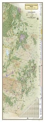
National Geographic's map of the Continental Divide Trail is ideal for fans and hikers of this magnificent National Scenic Trail. It makes a great planning tool or as reference to track progress on the 3,100 plus mile length. This beautiful map shows the entire length of the trail from Mexico to Canada through New Mexico, Colorado, Wyoming, Idaho, and Montana. A unique elevation profile highlights the trail's peaks and valleys, and an informative mileage chart shows the distance between key locations. Also highlighted on this map are passes, peaks, national forests, national parks, state parks, and Indian reservations. Additional points of interest include lodges and campgrounds near the trail. The map is packaged in a full color box that is perfect for gift giving. The box includes details about the map with its size and scale as well as a large section of the map that displays the cartography found inside
| Erscheint lt. Verlag | 20.12.2017 |
|---|---|
| Verlagsort | Evergreen |
| Sprache | englisch |
| Maße | 515 x 65 mm |
| Themenwelt | Reisen ► Karten / Stadtpläne / Atlanten ► Welt / Arktis / Antarktis |
| Naturwissenschaften ► Geowissenschaften ► Geografie / Kartografie | |
| ISBN-10 | 1-56695-748-6 / 1566957486 |
| ISBN-13 | 978-1-56695-748-9 / 9781566957489 |
| Zustand | Neuware |
| Haben Sie eine Frage zum Produkt? |
Mehr entdecken
aus dem Bereich
aus dem Bereich
1:30 Mio. mit Posterleisten, mit Oberflächenlaminat
Karte (gerollt) (2023)
INTERKART Landkarten & Globen (Verlag)
25,90 €


